Summary
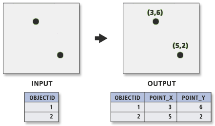
Adds the fields POINT_X and POINT_Y to the point input features and calculates their values. It also appends the POINT_Z and POINT_M fields if the input features are Z- and M-enabled.
Illustration

Usage
If the POINT_X, POINT_Y, POINT_Z, and POINT_M fields exist, their values are recalculated.
The output POINT_X and POINT_Y field values are based on the coordinate system of the dataset, not the coordinate system of the map display. To force the POINT_X and POINT_Y values to be in a coordinate system different than the input dataset, set the Output Coordinate System environment.
If points are moved after using Add XY Coordinates, their POINT_X and POINT_Y values, and POINT_Z and POINT_M values—if present—must be recomputed by running Add XY Coordinates again.
The Project tool does not modify the values of POINT_X, POINT_Y, POINT_Z, or POINT_M fields.
If the input features are in a geographic coordinate system, POINT_X and POINT_Y represent the longitude and latitude, respectively.
Caution:
This tool modifies the input data. See Tools that do not create output datasets for more information and strategies to avoid undesired data changes.
Syntax
AddXY(in_features)
| Parameter | Explanation | Data Type |
in_features | The point features whose x,y coordinates will be appended as POINT_X and POINT_Y fields. | Feature Layer |
Derived Output
| Name | Explanation | Data Type |
| out_features | The updated input features. | Feature Layer |
Code sample
The following Python window script demonstrates how to use the AddXY function in immediate mode.
import arcpy
arcpy.env.workspace = "C:/data"
arcpy.Copy_management("climate.shp", "climateXYpts.shp")
arcpy.AddXY_management("climateXYpts.shp")The following Python script demonstrates how to use the AddXY function in a stand-alone script.
# Name: AddXY_Example2.py
# Description: Adding XY points to the climate dataset

# Import system modules
import arcpy
from arcpy import env

# Set workspace
env.workspace = "C:/data"

# Set local variables
in_data= "climate.shp"
in_features = "climateXPpts2.shp"

# Copying data to preserve original dataset
# Execute Copy
arcpy.Copy_management(in_data, in_features)

# Execute AddXY
arcpy.AddXY_management(in_features)Licensing information
- Basic: Yes
- Standard: Yes
- Advanced: Yes