Available with Business Analyst license.
Summary
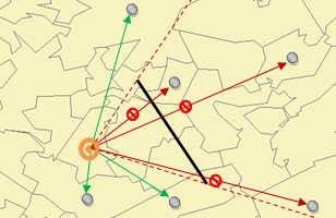
Allows the addition of polygon or line features to prevent or restrict the growth of territories.
Illustration

Usage
Line or polygon layers can be used as barriers.
New features can be added to an existing barrier.
Each level can contain both an impedance and a restricted area.
Syntax
AddTerritoryBarriers(in_territory_solution, level, in_barrier_features, {barrier_type}, {append_data})| Parameter | Explanation | Data Type |
in_territory_solution | The Territory Design solution layer that will be used in the analysis. | Group Layer; Feature Dataset; String |
level | The level to which the barriers will be applied. | String |
in_barrier_features | Line or polygon features used as a barrier. | Feature Layer |
barrier_type (Optional) | Specifies the type of barrier.
| String |
append_data (Optional) | Specifies whether to append or replace the records to the barriers layer.
| Boolean |
Derived Output
| Name | Explanation | Data Type |
| out_territory_solution | The updated territory solution. | Group Layer |
Code sample
The following Python window script demonstrates how to use the AddTerritoryBarriers tool.
import arcpy
arcpy.td.AddTerritoryBarriers("in_territory_solution", "Level[1]", "in_barrier_features", "IMPEDANCE", "REPLACE_DATA")
Environments
Licensing information
- Basic: Requires Business Analyst
- Standard: Requires Business Analyst
- Advanced: Requires Business Analyst