Available with Aviation Airports license.
Label classes can be created to display airport sign labels and symbols. Labels are useful on their own, but they can also be used for developing airport sign annotation. This is done by first setting up and refining label classes for the front and back of AirportSign features, then converting those labels to feature-linked annotation. Setting up and rendering label classes is an initialization workflow that allows interactive modification of parameters to create the desired size and default label position of AirportSign features before they are committed to annotation.
You may use labeling while creating and editing AirportSign features during initial creation of your airport sign point data.
Once the data is initialized, the labels can be converted to feature-linked annotation. All subsequent airport sign editing will be reflected in its feature-linked annotation, and the label classes will no longer need to be rendered.
The Airports Product Data package, available on My Esri, includes an AirportSign layer file which can be used to apply labeling properties and symbology on your airport sign features.
Note:
The airport sign layer file requires that you have the SimHei font installed to your computer. At Windows 10, the SimHei font is no longer installed by default.
To install the SimHei font, browse to Control Panel > Appearance and Personalization > Fonts and click Download fonts for all languages.
Set up the map for the AirportSign layer
- Start ArcGIS Pro and open a map within a project.
- In the Contents pane, right-click the map and choose Properties.
The Map Properties window appears.
- Click General in the menu to the left of the Map Properties window, then set the Reference scale value for the AirportSign labels. For example, 1:1000.
- Click OK.
- Right-click on the map in the Contents pane and choose Labeling.
- Check the Use Maplex Label Engine checkbox.
Add the airport signs layer file to the map.
You can use the AirportSign_frontBack_labels layer file in the Airports Product Files data package to symbolize your airport signs.
- Click the Map tab.
- In the Layer group, click Add Data.
- In the file explorer window, navigate to the install directory for the Airports Product Data package.
Note:
The default install directory for this file is C:\Users\Public\Documents\ArcGIS Aviation Airports\Product Files\<version number>\Layers\AirportSign_frontBack_labels.lyrx.
- Select the AirportSign_frontBack_labels.lyrx file.
- Click OK.
The AirportSign feature layer appears in the Contents pane.
- ClickRepair Broken Data Source next to the AirportSign feature layer in the Contents pane.
A file explorer window appears.
- Browse to the AirportSign feature class in your Aviation Airports geodatabase.
- Select the AirportSign feature class.
- Click OK.
Set the AirportSign elevation units
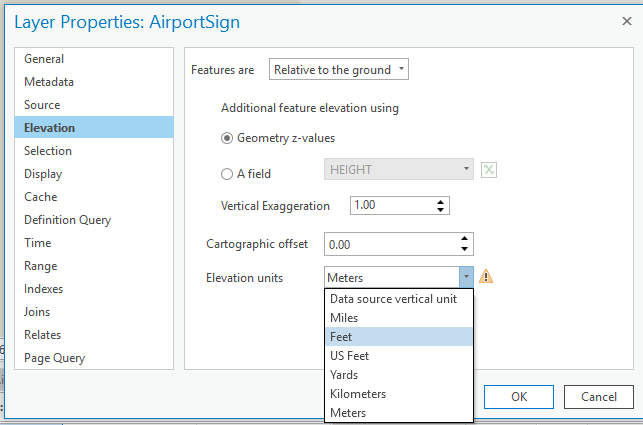
- Double-click the AirportSign feature layer in the Contents pane to open its layer properties.
- Click Elevation on the left side of the Layer Properties window.
- Click the Elevation units drop-down arrow and select an elevation unit for your airport signs.
- Click OK.
