The Cell Size Projection Method environment setting uses the defined method to control the calculation of the output raster cell size when datasets are projected during analysis.
The projected cell size can be calculated using one of the following three methods:
- Convert units
- Preserve resolution
- Center of extent
How cell size is calculated with the Convert units method
In the Convert units method, the way units are converted depends on the types of coordinate systems involved. There are three scenarios as identified below.
Project between different projected coordinate systems
When projecting from one projected coordinate system (PCS) to another PCS, linear units are converted by the relevant factor, if necessary. If the map units are the same, there will be no linear unit conversion while projecting between two PCSs. If the linear units are different between the original extent and the projected extent, the linear unit conversion will take place. For example, if the map units are in meters and the projected units are in feet, 10 meters from the original extent will represent 32.8084 feet in the projected extent.
Transform between different geographic coordinate systems
When transforming from one geographic coordinate system (GCS) to another GCS, angular units are converted.
Project between PCS and GCS
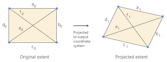
When projecting from GCS to PCS, or PCS to GCS, the output cell size is calculated based on the average of the ratios of the four sides and the two diagonals of the projected extent to the original extent. The following figure represents the original extent in PCS and the projected extent in GCS. The lengths of the sides and diagonals of the original extent are a0, b0, c0, d0, e0 and f0, and the corresponding lengths in the projected extent are a1, b1, c1, d1, e1 and f1.

The cell size of the projected extent is computed as follows:
CellSizeprojected = 1/6(a1/a0 + b1/b0 + c1/c0 + d1/d0 + e1/e0 + f1/f0) * CellSizeoriginalLimitations
This approach has the following limitations:
- It does not account for distortion when projecting from one PCS to another. For example, the projected distance of 1 meter in a UTM zone at a given location may not cover the same ground distance as 1 meter in an Albers projection.
- When projecting from GCS to PCS, or PCS to GCS, only the four corner points of the original extent are projected to calculate the length of the side and diagonals. This may introduce excessive distortion, depending on the projection and the extent.
To avoid these limitations, it is recommended that you specify the cell size projection method appropriate for the analysis.
How cell size is calculated with the Preserve resolution method
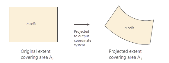
In the Preserve resolution method, the same number of square cells are preserved in the projected extent as are in the original extent. The output cell size is calculated based on the ratios of the areas of the projected extent to the original extent. This method calculates the average size of a square cell more accurately for all combinations of GCS and PCS than the default Convert units method.
If the areas of the original rectangular extent and (shape preserving) projected extent are A0 and A1, then the areas of the square cells, respectively, are:
ca0 = A0/nand,
ca1 = A1/n
Since the number of cells n remains constant for both cases, the ratio of the area of extent to the area of the square cell are equal,
A0/ca0 = A1/ca1The output cell area can be represented as:
ca1 = (A1/A0) * ca0Therefore, the output cell size is:
CellSizeprojected = √((A1/A0) * ca0)In this method, the cell size conversion factor is:
√(A1/A0)Limitation
The limitation of this method is that the output cell size depends on a specific geographic location; consequently, it may not be appropriate to use one cell size for performing analysis when tiling rasters over a large area. To avoid this, use the same raster dataset to specify cell size while performing raster analysis for different tiles over a large area.
How cell size is calculated with the Center of extent method
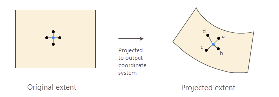
The Center of extent method projects the center of the original extent to the output coordinate system. The output cell size is calculated by taking the average of the projected distances from the center point to its four adjacent points.
The following figure represents five points in the original extent, where one of the points is at the center, and it is surrounded by the four other points at a distance of the original cell size from the center point.

The new cell size is calculated by taking the average of the projected lengths as follows:
CellSizeprojected = 1/4(a + b + c + d)- where:
a, b, c and d are the distances from the center point to its four adjacent points in the projected extent.
Limitation
The limitation of the Center of extent method is the same as that of the Preserve resolution method. Use the same raster dataset to specify cell size while performing raster analysis for different tiles over a large area.