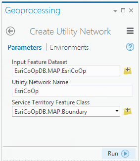
A utility network is established as a foundation that includes the utility network and structure network classes. After initial creation, one or more domain networks can be added as part of the configuration process. While multiple domain networks can be added, a single structure network is shared across domain networks. Collectively, the Create Utility Network and Add Domain Network tools generate the appropriate network classes that will be configured to accommodate industry-specific needs.
Create Utility Network tool
The Create Utility Network tool is used to create a utility network in the specified geodatabase feature dataset. During creation of a utility network, the structure network is also created. The structure network classes will be shared across all of the domain networks, as they are used to model structural features that provide support for or contain other features.
Requirements and prerequisites
The requirements and prerequisites for creating a utility network are as follows:
- An existing feature dataset to use as the input feature dataset.
- When working with an enterprise geodatabase, the input feature dataset must be from a database connection established as a database-authenticated user. This user must have database privileges to create content and cannot be an OS-authenticated user, a database administrator, or the geodatabase administrator account. The connected user will become the database utility network owner.
- An existing m- and z-enabled polygon feature class containing features to serve as the service territory feature class.
- The service territory feature class must reside in the input feature dataset. The extent of the features in the service territory feature class are used to define the network extent for the utility network.
- For deployments on an enterprise geodatabase—ArcGIS Enterprise must be 10.6 or later. The ArcGIS Pro and ArcGIS Enterprise versions determine the utility network version created. For more information, see ArcGIS platform compatibility.
License:
The active portal account must be licensed with the ArcGIS Utility Network user type extension to create, publish, and work with a utility network in an enterprise geodatabase.The geodatabase version must be 10.8.1.2.6 or later.
- An active ArcGIS Enterprise portal must be added to the project with a portal account signed in that has privileges to publish content; this includes privileges to publish server-based layers as well as create, update, and delete content. The default Publisher role includes these privileges. The active ArcGIS Enterprise portal account will be recorded in the network properties as the portal utility network owner.
- ArcGIS Server must be federated with Portal for ArcGIS. Configuring a base ArcGIS Enterprise deployment is recommended but not required.
Supported geodatabases
A utility network can be created in a file or enterprise geodatabase. To create a utility network in an enterprise geodatabase, the database platform must meet the minimum release in the table below. For more information, refer to the database requirements for ArcGIS Pro.
| Database platform | Minimum release |
|---|---|
| SQL Server | SQL Server 2016 |
Oracle 12.1.0.2 | |
| PostgreSQL | PostgreSQL 10.12 |
| SAP HANA | HANA 2.0 SPS04 |
Create a utility network in a geodatabase
To create a utility network in a geodatabase, complete the following steps:
- On the Analysis tab, in the Geoprocessing group, click Tools
 to open the Geoprocessing pane.
 - In the Geoprocessing pane, search for and select Create Utility Network.
- For Input Feature Dataset, browse to an existing feature dataset
 within your geodatabase. By default, geodatabases are created under Databases
  in the Catalog pane.
 - Specify a name for the Utility Network Name parameter.
- Specify a polygon feature class
 for the Service Territory Feature Class parameter. This feature class must reside in the input feature dataset provided in step 3.
 This feature class represents the geographical extent the domain networks cover. It is used to restrict edits so that features are not created outside of a network area. The utility network's extent (editing area) will be the extent of the combined polygons.
- Click Run to execute the tool.

The feature dataset is now populated with a utility network dataset and the structure network classes.
To store and manage features specific to a utility, one or more domain networks can be added to the utility network. To learn more, see Add a domain network.