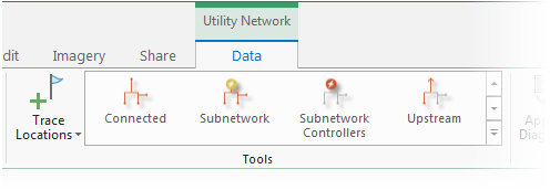
You can find features upstream or downstream from a starting point location in a subnetwork using the Trace tool with the Upstream or Downstream trace type set.
To learn more, see Utility network trace types.
Requirements
To perform an upstream or downstream trace, the following requirements must be met:
- The subnetwork has one or more subnetwork controllers.
- The network topology must be enabled.
- One or more starting points must exist.
- When working with an enterprise geodatabase, the Input Utility Network parameter must be from a utility network service.
Note:
In the case of both types of traces, if a subnetwork controller is not present or not connected to the specified subnetwork, an error message is returned and the trace fails.
Trace upstream features
- Ensure the utility network is available in an active map view and click the Data tab under Utility Network on the ribbon.

The Utility Network Data tab is activated.
- Ensure one or more starting points exist in the map view. In the Tools group, click the Trace Locations command to open the Trace Locations pane. Set Starting Points and Barriers to use in the trace.
For Upstream traces, starting points must be set, and barriers are optional.
- On the Data tab, in the Tools group, click Upstream in the tools gallery.

The Trace tool opens for the utility network in the active map using the specific Trace Type.
- For the Domain Network parameter, choose the domain network where you want to start the trace.
- To refine the traceable area, specify a tier for the Tier parameter.The trace configuration is loaded into the tool based on the Tier Definition.
- If you want to span multiple tiers, specify a tier for the Target Tier parameter.
- Apply additional configuration parameters as needed. Reference the Trace tool for a full list of tool parameters. Also see Configure a trace.
- Click Run.
Features upstream from the starting points are returned as a selection set.
Trace downstream features
- Ensure the utility network is available in an active map view and click the Data tab under Utility Network on the ribbon.

The Utility Network Data tab is activated.
- Ensure one or more starting points exist in the map view. In the Tools group, click the Trace Locations command to open the Trace Locations pane. Set Starting Points and Barriers to use in the trace.
For Downstream traces, starting points must be set, and barriers are optional.
- On the Data tab, in the Tools group gallery, click Downstream. This will open the Trace tool for the utility network in the active map using a downstream Trace Type.
Tip:
Use the down arrow to browse in the tools gallery for Downstream.

- For the Domain Network parameter, choose the domain network where you want to start the trace.
- To refine the traceable area, specify a tier for the Tier parameter.The trace configuration is loaded into the tool based on the Tier Definition.
- If you want to span multiple tiers, specify a tier for the Target Tier parameter.
- Apply additional configuration parameters as needed. Reference the Trace tool for a full list of tool parameters. Also see Configure a trace.
- Click Run.
Features downstream from the starting point are returned as a selection set.