| Label | Explanation | Data Type |
Input Level Features
| The input polygon features representing levels in facilities. In the Indoors model, this will be the Levels layer. The tool honors selections and definition queries applied to the layer. | Feature Layer |
Input Detail Features
| The input polyline features representing architectural details that can serve as barriers to travel within a facility. In the Indoors model, this will be the Details layer | Feature Layer |
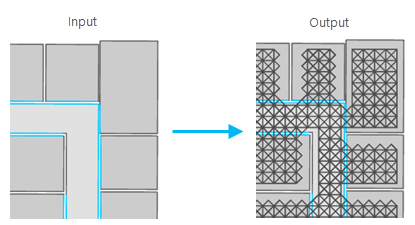
Target PrelimPathways | The feature class or feature layer to which generated pathway polylines will be written. In the Indoors model, this will be the PrelimPathways layer. | Feature Layer |
Lattice Rotation (Optional) | The number of degrees by which the input floors' primary travel direction is rotated clockwise from due west. If left blank, the tool will calculate a value based on the minimum bounding rectangle of each floor. The value must be between 0.0 and 180.0. | Double |
Lattice Density (Optional) | The longest distance allowed between nodes in the generated lattice of pathways. The tool uses the unit of measure from the coordinate system of the Indoors dataset. The default value is 0.6. The value must be between 0.25 and 2.9. | Double |
Restricted Unit Features
(Optional) | The input polygon features representing restricted and unrestricted spaces within a facility. In the Indoors model, this will be the Units layer. | Feature Layer |
Restricted Unit Expression
(Optional) | An SQL expression used to select the Restricted Unit Features parameter values in which the tool will not generate pathways. | SQL Expression |
Detail Expression
(Optional) | An SQL expression used to select the Input Detail Features parameter values across which the tool will not generate pathways. | SQL Expression |
Derived Output
| Label | Explanation | Data Type |
| Updated Pathways | The updated Target Pathways layer. | Feature Class |
