Available with Image Analyst license.
A Sentinel-1 Level 1 synthetic aperture radar (SAR) image must be processed before it can be used for visualization or analysis. Issues that need to be addressed include updating orbit data, removing thermal noise, calibrating to retrieve a meaningful backscatter value, mitigating speckle, removing radiometric and geometric distortions, and rendering images with a large value range.
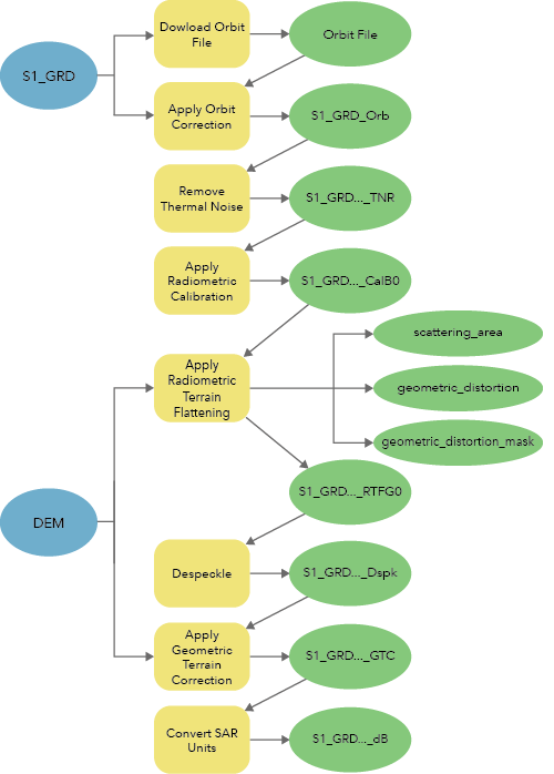
The Synthetic Aperture Radar toolset, in the Image Analyst toolbox, contains eight tools to generate calibrated, terrain-corrected, analysis-ready imagery data from Sentinel-1 Ground Range Detected (GRD) data. The following tools are used to generate analysis-ready Sentinel-1 GRD data, as shown in the table and diagram below.
| Tool | Description |
|---|---|
Downloads the updated orbit files for the input synthetic aperture radar (SAR) data. | |
Updates the orbital information in the synthetic aperture radar (SAR) dataset using a more accurate orbit state vector (OSV) file. | |
Corrects backscatter disturbances caused by thermal noise in the input synthetic aperture radar (SAR) data, resulting in a more seamless image. | |
|
Converts the input synthetic aperture radar (SAR) reflectivity into physical units of normalized backscatter by normalizing the reflectivity using a reference plane. | |
Corrects the input synthetic aperture radar (SAR) data for radiometric distortions due to topography. | |
Corrects the input synthetic aperture radar (SAR) data for speckle, which is a result of coherent illumination that resembles a grainy or salt and pepper effect. | |
Orthorectifies the input synthetic aperture radar (SAR) data using a range-Doppler backgeocoding algorithm. | |
Converts the scaling of the input synthetic aperture radar (SAR) data between amplitude and intensity, between linear and decibels (dB), and between complex and intensity. |

Sentinel-1 GRD processing considerations
When you download and apply the orbit files, consider the type of orbit state vectors (OSVs) you'll use. The following types of OSVs are available for the Sentinel-1 product:
- Predicted—Provided with the Sentinel-1 Level 1 GRD and Single Look Complex (SLC) auxiliary products
- Restituted—Available through the European Space Agency (ESA) within three hours of image acquisition
- Precise—Available through ESA within three weeks of image acquisition
It is recommended that you update the OSVs to restituted or precise once they are available.
Due to the Sentinel-1 Terrain Observation with Progressive Scans (TOPS) acquisition mode, the thermal noise in Sentinel-1 products varies for individual subswath scans. Thermal noise commonly manifests as a sharp contrast between the subswath scans.