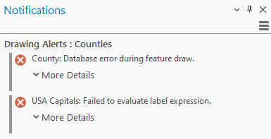
As you work on a map, scene, layout, link chart, or diagram, you may receive drawing alert notifications. These notifications let you know when there are issues preventing your data from displaying correctly or completely. If a warning icon  or alert icon
  appears on the status bar (at the bottom of the view), a drawing error has occurred while drawing a layer, dataset, or item in an open view.

The project may continue to draw other data, but in almost all cases, drawing is not complete if an alert is received.
Drawing alerts occur for a variety of reasons. They fall into many categories, and each alert includes information about the specific issue. To guarantee an optimal map, it is recommended that you review and repair the problems indicated by each alert, if possible.
Act on a drawing alert
An alert icon appears at the bottom of the project view with the cumulative number of errors that occurred as each drawing phase completes. You can click the icon, or press Alt+W, to open the Notifications pane and read the details provided by the alert to determine what action is required.
To find the problem layer, hover over the alert and click Show More > Select Layer. To dismiss an alert, hover over the alert again and click the Close button  to close.

Due to their importance, alerts cannot be completely suppressed in ArcGIS Pro. Dismissed alerts reappear if the map is refreshed or you move, pan, or zoom around the map. However, they do not prevent or cancel the drawing of other layers or maps.
For more information, see Act on a notification.
Drawing alert types
Drawing alerts can include the following types of messages:
- Database errors—for example, a field used in a layer's definition query is not found in your database.
- Service layer errors—for example, the feature query limit threshold was exceeded.
- Expression parsing errors—for example, the syntax used in an Arcade expression is incompatible with your version of the software.
The cause of the drawing alert varies, due to the complexity of drawing data in different formats from different sources.
Common drawing alerts
| Issue | Solution |
|---|---|
A server error occurred while drawing the map. | Review the message details, and consult your server's documentation for further information. |
An expected Field was not found or could not be retrieved properly. | Review and ensure the specified field is still present in the dataset. |
Database error during feature draw. | Do one of the following:
|
Edits are in progress or completed for a large number of features in a scene layer. This may result in reduced drawing performance for the scene layer. Consider rebuilding your scene layer cache before continuing to edit. | Rebuild the web scene layer cache. For more information, see Edit a scene layer with associated feature layer. |
Excessive draw requests. | For more information, see Excessive draw requests. |
Failed to evaluate label expression. | Review the WHERE clause's syntax. If an error occurred while parsing the clause, review the details and the specified fields. If the fields are still present in the database, ensure the name of the field is correct in the expression, does not match any other fields, and is a supported field type in Arcade. |
Feature limit exceeded. Not all features are displayed. Zoom in to see more features. | If you are using a web feature layer, zoom in to a smaller area so that fewer features are displayed. |
GPU resources exceeded. | Close some map views or modify layer settings to reduce the amount of used resources. See Graphics adapter resources for more information. |
Graphics hardware change. | See Graphics hardware change for further information. |
Invalid spatial reference. | Detect and repair any feature classes with invalid spatial references. |
Service does not support the map's coordinate system. | Choose a coordinate system for the map that is supported by the server or service. Review your server's documentation for further information. |
This dataset's surface constraint(s) could not be opened | Ensure the surface constraints used in your LAS dataset use the specified name, are in the expected locations, and are accessible. |
Unsupported coordinate system. | This alert is most commonly raised when symbolizing your layer with heat map symbology or feature aggregation. These types of visualizations do not support all coordinate systems. To resolve the alert, set the map's coordinate system to one that supports your chosen symbolization method. |