| Label | Explanation | Data Type |
Input Point Cloud
| The point cloud scene layer package (*.slpk file) or I3S point cloud scene layer service that will be used to generate an elevation raster. An I3S point cloud scene layer service must have the export property enabled to be processed. | Scene Layer; File |
Cell Size
| The length and width of each cell in the output raster. | Linear Unit |
Output Raster | The location and name of the output raster. When storing a raster dataset in a geodatabase or in a folder such as an Esri Grid, do not add a file extension to the name of the raster dataset. A file extension can be provided to define the raster's format when storing it in a folder, such as .tif to generate a GeoTIFF or .img to generate an ERDAS IMAGINE format file. If the raster is stored as a .tif file or in a geodatabase, the raster compression type and quality can be specified using geoprocessing environment settings. | Raster Dataset |
Cell Assignment Type
(Optional) | Specifies the method that will be used for assigning values to cells containing points.
| String |
Void Fill Method
(Optional) | Specifies the method that will be used for interpolating the values of cells within the interpolation zone that do not contain points.
| String |
Z Factor
(Optional) | The factor by which z-values will be multiplied. This is typically used to convert z linear units to match x,y linear units. The default is 1, which leaves the z-values unchanged. | Double |
Summary
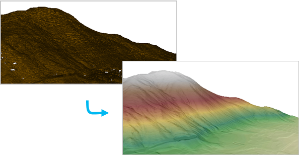
Creates a raster surface from height values in a point cloud scene layer package (*.slpk file) or Indexed 3D Scene (I3S) service.
Illustration

Usage
This tool derives a raster surface by estimating cell values through binning in which the point cloud is divided into rectangular areas that match the output cell size. The raster values are assigned based on the options specified for the Cell Assignment Type and Void Fill Method parameters. The Cell Assignment Type parameter controls how the values for cells that contain points are defined, and the Void Fill Method parameter controls how the values for cells that do not contain points are determined.
When using the Natural Neighbor option for the Void Fill Method parameter to fill void cells, consider limiting the use of this option to point clouds that have a concave distribution. If this option is used with points that have a convex distribution, it may take a long time to interpolate between long void areas.
This tool extracts point data within the processing extent to temporary files in the scratch workspace. The amount of scratch workspace required is related to the number of points within the processing extent. If the entire point cloud scene layer is processed, the scratch files will use approximately the same amount of space as the input.
The points in the point cloud scene layer can be filtered on the Point Filter tab on the Layer Properties dialog box. When point filters are applied, only the points that are selected in the filter will be used for interpolating a raster.
Parameters
arcpy.conversion.PointCloudToRaster(in_point_cloud, cell_size, out_raster, {cell_assignment}, {void_fill}, {z_factor})| Name | Explanation | Data Type |
in_point_cloud | The point cloud scene layer package (*.slpk file) or I3S point cloud scene layer service that will be used to generate an elevation raster. An I3S point cloud scene layer service must have the export property enabled to be processed. | Scene Layer; File |
cell_size | The length and width of each cell in the output raster. | Linear Unit |
out_raster | The location and name of the output raster. When storing a raster dataset in a geodatabase or in a folder such as an Esri Grid, do not add a file extension to the name of the raster dataset. A file extension can be provided to define the raster's format when storing it in a folder, such as .tif to generate a GeoTIFF or .img to generate an ERDAS IMAGINE format file. If the raster is stored as a .tif file or in a geodatabase, the raster compression type and quality can be specified using geoprocessing environment settings. | Raster Dataset |
cell_assignment (Optional) | Specifies the method that will be used for assigning values to cells containing points.
| String |
void_fill (Optional) | Specifies the method that will be used for interpolating the values of cells within the interpolation zone that do not contain points.
| String |
z_factor (Optional) | The factor by which z-values will be multiplied. This is typically used to convert z linear units to match x,y linear units. The default is 1, which leaves the z-values unchanged. | Double |
Code sample
The following sample demonstrates the use of this tool in the Python window:
import arcpy
arcpy.env.workspace = "C:\GIS_Data"
arcpy.ddd.PointCloudToRaster("GT_Mountains.slpk", "10 Meters", "GT_surface.tif",
                             "MAXIMUM", "LINEAR", 0.3048)
Environments
Licensing information
- Basic: Requires Spatial Analyst or 3D Analyst
- Standard: Yes
- Advanced: Yes