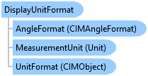
DisplayUnitFormat Class
In This Topic
Provides unit formatting within a Pro project
Object Model

Syntax
public class DisplayUnitFormat : ArcGIS.Desktop.Framework.Contracts.PropertyChangedBase, System.ComponentModel.INotifyPropertyChanged
Public Class DisplayUnitFormat
   Inherits ArcGIS.Desktop.Framework.Contracts.PropertyChangedBase
   Implements System.ComponentModel.INotifyPropertyChanged
Remarks
Supports property notification
Example
Get the Current Map Location Unit
//var map = MapView.Active.Map;
//Must be on the QueuedTask.Run()

//Get the current location unit
var loc_unit = map.GetLocationUnitFormat();
var line = $"{loc_unit.DisplayName}, {loc_unit.UnitCode}";
System.Diagnostics.Debug.WriteLine(line);
Get the Available List of Map Location Units
//var map = MapView.Active.Map;
//Must be on the QueuedTask.Run()

//Linear location unit formats are not included if the map sr
//is geographic.
var loc_units = map.GetAvailableLocationUnitFormats();
Format a Location Using the Current Map Location Unit
var mv = MapView.Active;
var map = mv.Map;

QueuedTask.Run(() =>
{
  //Get the current view camera location
  var center_pt = new Coordinate2D(mv.Camera.X, mv.Camera.Y);
  //Get the current location unit
  var loc_unit = map.GetLocationUnitFormat();

  //Format the camera location
  var str = loc_unit.FormatLocation(center_pt, map.SpatialReference);
  System.Diagnostics.Debug.WriteLine($"Formatted location: {str}");
});
Set the Location Unit for the Current Map
var mv = MapView.Active;
var map = mv.Map;

QueuedTask.Run(() =>
{
  //Get the list of available location unit formats
  //for the current map
  var loc_units = map.GetAvailableLocationUnitFormats();

  //arbitrarily use the last unit in the list
  map.SetLocationUnitFormat(loc_units.Last());
});
Get the Current Map Elevation Unit
//var map = MapView.Active.Map;
//Must be on the QueuedTask.Run()

//If the map is not a scene, the default Project distance
//unit will be returned
var elev_unit = map.GetElevationUnitFormat();
var line = $"{elev_unit.DisplayName}, {elev_unit.UnitCode}";
System.Diagnostics.Debug.WriteLine(line);
Get the Available List of Map Elevation Units
//var map = MapView.Active.Map;
//Must be on the QueuedTask.Run()

//If the map is not a scene, the list of current
//Project distance units will be returned
var elev_units = map.GetAvailableElevationUnitFormats();
Format an Elevation Using the Current Map Elevation Unit
var mv = MapView.Active;
var map = mv.Map;

QueuedTask.Run(() =>
{
  //Get the current elevation unit. If the map is not
  //a scene the default Project distance unit is returned
  var elev_unit = map.GetElevationUnitFormat();

  //Format the view camera elevation
  var str = elev_unit.FormatValue(mv.Camera.Z);

  System.Diagnostics.Debug.WriteLine($"Formatted elevation: {str}");
});
Set the Elevation Unit for the Current Map
var map = MapView.Active.Map;

QueuedTask.Run(() =>
{
  //Trying to set the elevation unit on a map other than
  //a scene will throw an InvalidOperationException
  if (map.IsScene)
  {
    //Get the list of available elevation unit formats
    //for the current map
    var loc_units = map.GetAvailableElevationUnitFormats();
    //arbitrarily use the last unit in the list
    map.SetElevationUnitFormat(loc_units.Last());
  }

});
Inheritance Hierarchy
System.Object
ArcGIS.Desktop.Framework.Contracts.PropertyChangedBase
ArcGIS.Desktop.Core.UnitFormats.DisplayUnitFormat
Requirements
Target Platforms: Windows 11, Windows 10
ArcGIS Pro version: 3 or higher.
See Also