Many geoprocessing tools, including Spatial Join, Append, Merge, Feature Class To Feature Class, and Table To Table, have a parameter for controlling how attribute fields from the input datasets are processed and written, or mapped, to the output dataset—the Field Map parameter. In addition to transferring attribute fields from input to output, field mapping can also be useful for some common tasks, such as field concatenation, and calculating statistics, such as mean or sum.
The Field Map control is displayed as a list of output fields, and the corresponding field properties and source fields (the attribute fields from the input datasets that are mapped to each output field).
Output fields
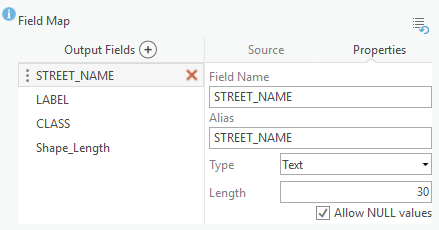
The list of Output Fields are the set of attribute fields that will be in the output dataset. You can select one or many output fields and delete each using the delete button  . You can add new output fields using the Add New Field button
  . You can hover over each output field to get a view of its name, alias, and type.
To modify the field order, click a field name and drag it to the preferred position. You can modify field Properties of the selected output field, such as the name and alias of the field, and the field type and associated properties.
Source fields
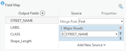
You can also view the Source fields of the selected output field. Source fields are the attribute fields from the input dataset that are mapped to the selected output field. The source fields associated with an output field will determine what attribute values from the input datasets are transferred to the output field in the output dataset.
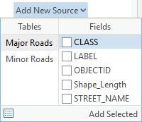
To pick source fields from your input datasets, click the Add New Source button, select an input table and field, and click the Add Selected button. 
Choosing source fields is especially important when reconciling schema differences between two datasets that are being processed. Tools such as Append and Merge combine multiple datasets into a single output dataset, so matching attribute fields is key to ensuring that the output meets your expectations. For example, if one of the datasets has an attribute field named Street_Name and the other dataset has an attribute field named Name_Of_Street, when the two datasets are combined, you want the values from those two attribute fields to be put into a single output attribute field. This is what field mapping is all about.
To match attribute fields from the input, add an output field or use an existing output field, and add a source field for each field you want matched. For example, you could specify that the output field Street should have two source fields: Street_Name from the first input dataset and Name_Of_Street from the second dataset.
You can use a merge rule to determine how multiple source fields should be handled. For example, you can concatenate text fields using a Join rule, or calculate a statistic for numeric fields using a Sum or Mean rule.
| Merge rule | Description |
|---|---|
| First | The first source value. |
| Last | The last source value. |
| Join | A concatenation of source values. You can use a delimiter to separate multiple input values. |
| Sum | The sum total of all source values. |
| Mean | The mean (average) of all source values. |
| Median | The median (middle) of all source values. |
| Mode | The source value that is the most common or has the highest frequency. |
| Minimum | The minimum (lowest) source value. |
| Maximum | The maximum (highest) source value. |
| Standard Deviation | The standard deviation of all source values. |
| Count | The number of source values, excluding null values. |
| Range | The absolute difference between the minimum and maximum source values. |