See what's new and improved in ArcGIS Pro 3.2.
Video overview
This video was created by the ArcGIS Pro development teams and the product support teams to highlight new functionality in this release.
Highlights
The Highlights section includes featured new functionality.
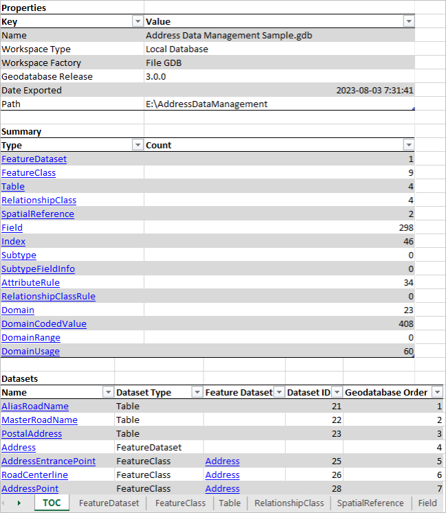
Generate a schema report
The schema of a geodatabase is made up of its datasets and their properties, relationships, and rules. The schema includes feature classes, tables, fields, domains, contingent values, attribute rules, and other geodatabase behavior. It can be thought of as your data model.
You can generate a schema report of your geodatabase in Excel, JSON, HTML or PDF format. Hyperlinks allow you to browse to and explore the elements of your schema, such as tables and feature classes, as well as their fields, properties, and behavior. The schema report comprehensively documents your data model and can serve many purposes. You can use it to plan and collaborate on schema updates, gather stakeholder support for the data model, assist in data migration workflows, keep historical records, and serve as a data dictionary.
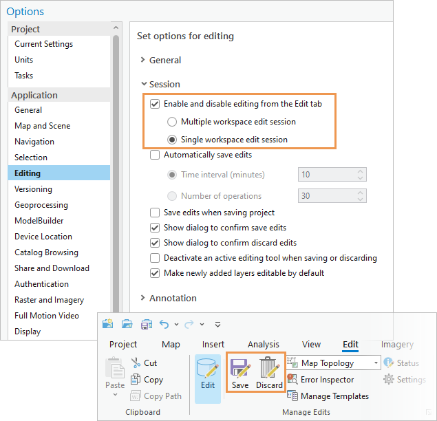
Choose and edit a single workspace
You can set edit session options to require editing to be enabled manually and either let ArcGIS Pro manage workspace edit sessions or specify that a workspace be selected manually. Explicitly starting editing is also available as a system administrator setting.
If you choose the option to use single workspace edit sessions, when you start editing in a non-versioned enterprise geodatabase workspace, you can manually save and discard edits on the Edit tab of the ribbon.
Keyboard shortcuts environment
A customizable environment for working with keyboard shortcuts is available on the new Keyboard Shortcuts dialog box. You can search for default shortcuts, modify existing shortcuts, and add new ones. You can display all shortcuts or just those that work in the current application state—for example, when a map view is active. Warnings are given if the same shortcut is assigned to commands that potentially conflict with each other.
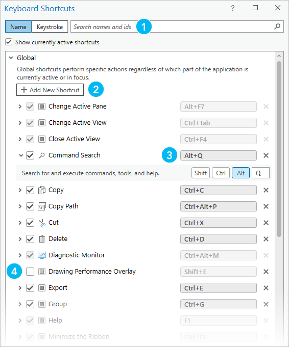
| Feature | Description |
|---|---|
 | Search for shortcuts by command name or keystroke. |
 | Browse to commands for which you want to add shortcuts. |
 | Assign different keystrokes to existing shortcuts. |
 | Turn off shortcuts to deactivate them. You can also delete shortcuts. All modifications can be reset to default values. |
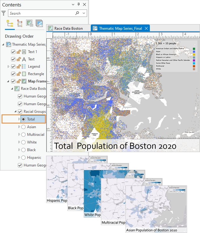
Thematic map series
You can now create thematic map series. In contrast to other map series types, in a thematic map series, the map frame on each page keeps the same extent, and the map data updates instead. Each page of the map series shows a different layer or group of layers in the map. The map series is built by iterating through all the features in a radio group layer, creating a page for each layer. Only one layer from the radio group is visible for each page; the other layers in the group are not visible. Layers outside the radio group are visible on each page in the map series.
New field data types
Four new field data types are available:
- Big integer—Supports 64-bit data. Stores whole numbers that exceed the range of -2.14 billion to 2.14 billion.
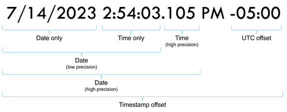
- Timestamp offset—Stores date and time values and can include a coordinated universal time (UTC) offset, such as 5/16/2023 10:00:00 AM -07:00.
- Date only—Stores a date value only, such as 2023-04-12.
- Time only—Stores a time value only, such as 10:00 AM.
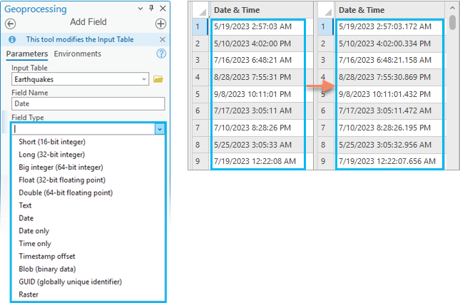
You can add these field data types when you create feature classes or tables, when you modify tables in the Fields view, or when you use geoprocessing tools such as Add Field.
In addition, you can migrate Object ID fields to 64-bit for geodatabase feature classes or tables that need to store more than 2.14 billion records. You can also migrate date fields to high-precision format to store time in milliseconds.
Oriented imagery
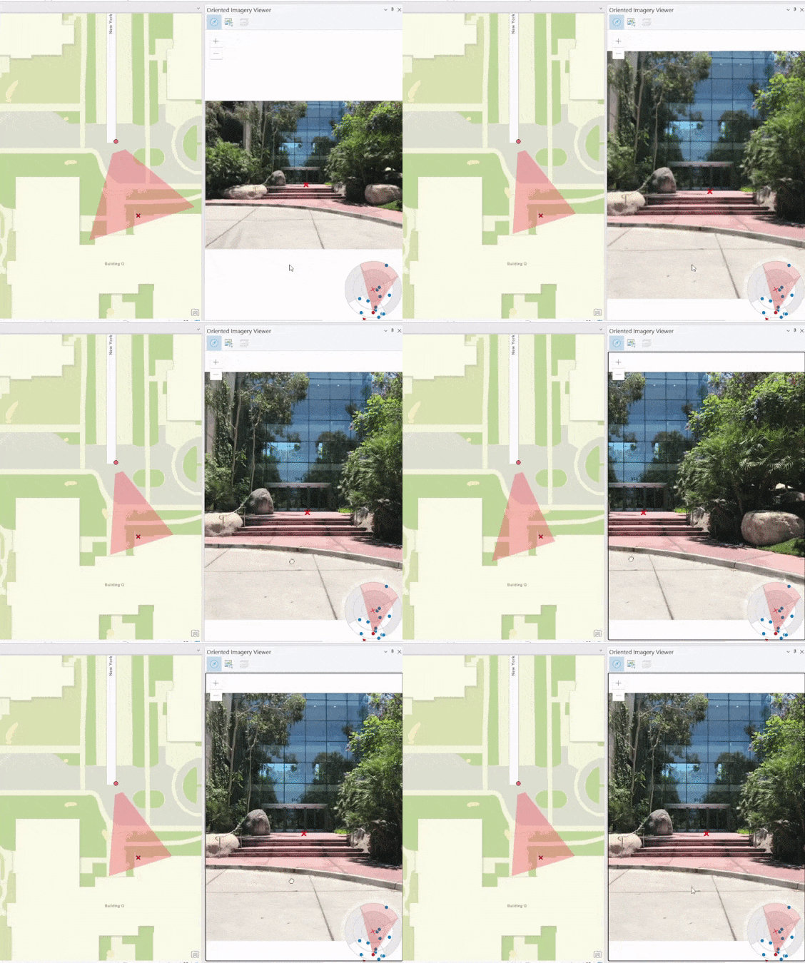
You can manage, visualize, and explore collections of oriented imagery on a map. Oriented imagery includes oblique drone imagery, close-range inspection images, and street-level images taken by mobile devices.
Once an image collection is assembled in an oriented imagery dataset, it can be viewed on a map as an oriented imagery layer (with an optional footprint layer). The oriented imagery layer is an extended point feature layer that records the geographic location in which an image was acquired, the path to the image, and key metadata. The footprint layer is a visual reference showing the map locations that correspond to each image's field of view.
When you click a map location, the Oriented Imagery Viewer pane displays the best available image of that location. The best image for the location is based on the distance of the camera from the selected location, the camera heading (direction), and the obliquity (camera pitch). As you pan and zoom the image, its footprint updates dynamically on the map. You can use the Navigation tool  and Image Gallery tool
  to explore additional images of the location.
Oriented imagery layers can be shared to ArcGIS Online or ArcGIS Enterprise 11.2 portals.
3D basemaps
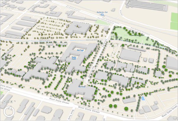
In local and global scenes, you can now add a 3D basemap when your active portal is set to ArcGIS Online. 3D basemaps enhance your scene with OpenStreetMap content that includes 3D buildings, trees, and labels. 3D basemaps are available for commonly used vector tile basemap types such as Topographic, Navigation, and Navigation (Dark).
Save items to a style
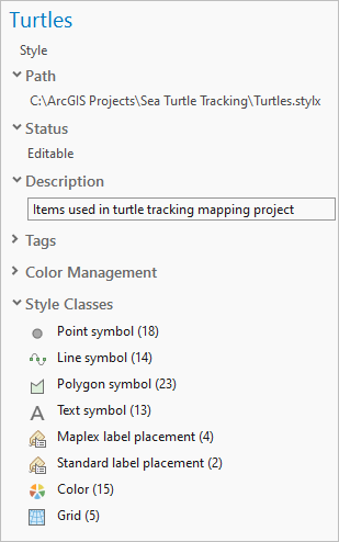
You can save all the style items in a project to a style. This takes all the symbols, colors, label placements, and layout items used in any map, scene, layout, or other project item and organizes them into one style. The style items are categorized by their associated project item, such as a layer or layout.
You can allow duplicates in the style—for example, there can be two versions of the same color, one used for labels in a map and another for the title of a layout. Optionally, you can streamline the style by saving only one instance of each duplicate.
Unless otherwise specified, the style has the same name as the project and is stored in the home folder. It is automatically added to the current project, where you can manage the style to edit style item names, tags, and other properties.
Performance and productivity
Performance and productivity have been improved in ArcGIS Pro 3.2. Some examples are listed below; you can find more throughout the topic and elsewhere in the help.
Performance
- CAD text symbology has been improved and renders more quickly. See what's new in CAD.
- You can draw point clouds using squares instead of circles. See what's new in 3D Analyst.
- Drawing is faster when you revisit areas in 3D scenes. See what's new in 3D scenes and scene layers.
- The Points to Line geoprocessing tool was rewritten for better performance. See what's new in the Data Management toolbox.
- Multipatch or 3D object feature layers shared as web scene layers to ArcGIS Online can use compressed textures for faster display. See what's new in Sharing.
Productivity
- The Auto Apply toggle button allows you to apply symbol property changes as you make them. See what's new in Symbols.
- You can choose whether to process selected, filtered, or highlighted records with a toggle button on geoprocessing tools. See what's new in Analysis and geoprocessing.
- You can copy and paste properties from one layer to another in a map or between maps. See what's new in Mapping and visualization.
- You can refresh the Fields view or Domains view of an attribute table with the current state of the dataset. See what's new in Geodatabases and databases.
- You can calculate statistics on attribute table fields without creating a chart. See what's new in Data Engineering.
- Portal items can be spatially filtered by map extent or location when you browse or search for content. See what's new in Projects.
- The search index has a new user interface and enhanced functionality for specifying indexing locations and schedules. See what's new in Indexing.
Get started
- A new user interface for accessing and customizing keyboard shortcuts is available. See Keyboard shortcuts environment in the Highlights section.
- More than 30 short how-to videos (one minute or less) were added to the documentation to demonstrate workflows. You can find examples related to editing, layouts, working with CAD data, and other ArcGIS Pro workflows.
- You can turn on a drawing performance overlay with a keyboard shortcut to get drawing statistics for maps and scenes.
- The Navigate maps and scenes quick-start tutorial has a new section for navigating a map using the keyboard.
Analysis and geoprocessing
General
- When a geoprocessing tool input has a selection, highlight, or filter, you can use the toggle button to process all input records or a subset.

- Many geoprocessing tools with a Field Type parameter that supports the Long field type now also support the Big integer (64-bit integer) field type. Similarly, many tools that support the Date field type support the Date only, Time only, and Timestamp offset field types. See New field data types in the Highlights section.
- The field map parameter—used by Append, Merge, Export Features, and other geoprocessing tools—was redesigned for improved productivity and functionality. (The ArcPy fieldmap object did not change.) For example, the following enhancements were made:
- The Field Properties window can be opened and resized to provide more space and increase the visibility of all field map capabilities.
- The merge rules in the user interface are now referred to as actions.
- The processing extent control was redesigned and enhanced with new features. Processing extent is a parameter on some geoprocessing tools and is found in the environment settings for projects and geoprocessing tools.
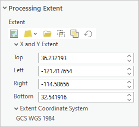
In the tool environment settings, you can specify the extent using the current display, a map layer, a specified dataset, or the intersection or union of inputs. - Geoprocessing tools honor highlighted records in a selection, which can be used to process a subset of the selected records.
- The geoprocessing application options include choices for displaying additional information messages when you run tools. The message categories include geographic transformations, command syntax, and diagnostic messages.
- Multifile feature connection (MFC) datasets that use Parquet source files can be visualized in maps and used as input for most geoprocessing tools.
- You can customize the icon and description for models and script tools displayed on the ribbon and Quick Access Toolbar by clicking the icon on the General tab of the Tool Properties dialog box.
Charts
- Support was added for multiseries grid pie charts and histograms.
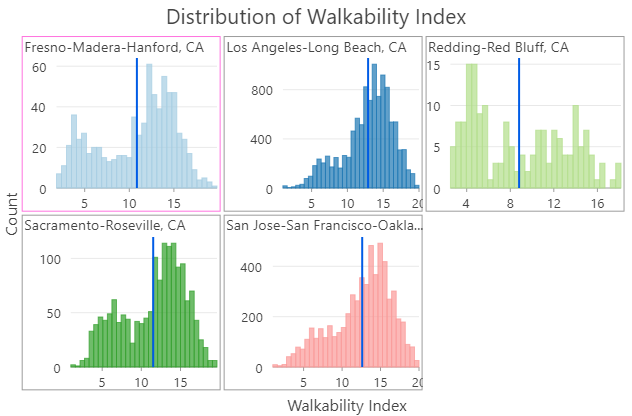
- The Capture To Clipboard export option allows you to copy chart graphics to the system clipboard.
- Temporal line charts can now snap to specific reference dates.
- Time binning options are available for temporal bar charts and matrix heat charts.
- Charts now use the Dark chart theme by default when ArcGIS Pro is set to the Dark application theme.
- A smoothing option has been added to line charts.
- When a chart references data in an enterprise geodatabase or cloud data warehouse, the Chart Properties pane displays a banner message with a toggle button. The button can be turned on to obtain performance improvements.
Data Engineering
- You can open a Data Engineering view and calculate the statistics for a field directly from the attribute table by right-clicking the field header and choosing Explore Statistics
 . You can also multiselect field headers to calculate statistics for multiple fields.
 - Pie charts are available on the Create Chart context menu for text and integer fields.
- In the statistics panel, various column titles and widths were shortened to reduce horizontal scrolling.
- Layers with 64-bit Object ID values are supported. You can calculate statistics for fields with the following data types: Big integer, Date only, Time only, and Timestamp offset. See New field data types in the Highlights section.
Geoprocessing history
- You can send Python code from the geoprocessing history to a notebook using the Send To Notebook command.
Geoprocessing services
- You can preserve composite data types when you publish and consume web tools and geoprocessing services.
- During publishing, you can preserve feature service and layer URLs using ArcGIS Pro or Python. The Python property is convertFeatureLayerURL.
- You can use a web tool or geoprocessing service to publish another web tool or geoprocessing service or a web layer with Python.
- You can provide an exact server version number to save as an offline service definition using ArcGIS Pro or Python. The Python property is offlineTarget.
- Toolboxes in .atbx format are no longer converted to .tbx format during packaging and publishing.
ModelBuilder
- The ModelBuilder application options include new settings for default font, layout orientation, and link routing.
- Find and replace filters help you refine searches.
- A new Open button
 on the ModelBuilder ribbon tab allows you to review messages from the model execution messages window.
 - New parameters on the Iterate Time tool create temporal slices using days of the week, months of the year, or subsets of data based on delay and duration values.
Raster functions
New raster functions:
- Gradient—Calculates the gradient along x, y, xy, or a given dimension.
- Region Pixel Count—Identifies connected regions with the same pixel value and returns a raster containing values for the number of pixels in the regions.
- SAR Indices—Computes various SAR indices, such as Radar Vegetation Index (RVI), Radar Forest Degradation Index (RFDI), and Canopy Structure Index (CSI).
Enhanced raster functions:
- Colormap—The Hillshade grayscale color map was added. Hillshade represents a 3D terrain surface with the sun's relative position taken into account.
- Remap—A new Replacement Value parameter was added.
- Zonal Statistics—Four new options were added to the Statistics Type parameter: Majority count, Majority percentage, Minority count, and Minority percentage.
Spatial statistics
- With a small number of limitations, all tools in the Spatial Statistics toolbox accept 64-bit Object ID and Big integer fields. See New field data types in the Highlights section.
Neighborhood Explorer
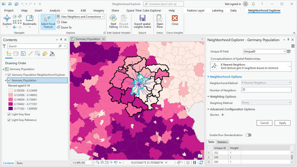
- Neighborhood Explorer is a new capability that allows you to configure, visualize, and refine conceptualizations of spatial relationships, which are often used by tools in the Spatial Statistics toolbox. Exploring neighborhoods is an important step in beginning and refining spatial statistics workflows.
Geoprocessing tools
- See Spatial Statistics toolbox for new and enhanced geoprocessing tools.
3D Analyst extension
Lidar and LAS datasets
- An option to render points as squares improves overall performance in a scene for point clouds.
- Files in .zlas format and LAS datasets that reference .zlas files are now editable.
Geoprocessing tools
- See 3D Analyst toolbox for new and enhanced geoprocessing tools.
Business Analyst extension
- You can build and edit infographic and classic report templates in ArcGIS Business Analyst Pro using a local dataset. Additionally, custom reports authored in ArcGIS Business Analyst Desktop can be edited and run in ArcGIS Pro.
- The reports generated by the Target Marketing workflow were redesigned to support infographic-style elements such as interactive charts, dynamic text, and filtering.
- The Target Marketing workflow includes accessibility enhancements. For example, keyboard navigation has been improved for the Four Quadrant Analysis chart, and the workflow has been optimized for users of screen readers.
Territory Design
- The Assign Territories pane is now the Modify Territories pane. The pane was redesigned to include support for locking and unlocking territories, viewing base feature attributes, and other common territory management capabilities.
Geoprocessing tools
- See Business Analyst toolbox for new and enhanced geoprocessing tools.
Geostatistical Analyst extension
- See Geostatistical Analyst toolbox for new and enhanced geoprocessing tools.
Image Analyst extension
Deep Learning
- Three additional deep learning framework models are supported: SIAMMASK, PSETAE, and DEEPSORT.
- Support for multiple GPUs is provided in training tools for pixel classification model types and object detection models.
Motion imagery
- Higher fidelity (4K) video formats are supported.
Stereo mapping
- Two 3D stereo mouse devices are supported: Stealth Mouse and Softmouse.
Synthetic aperture radar
- Previously available and new SAR tools work with the following new sensor types:
- Capella SICD
- ICEYE SICD
- RADARSAT-2 NITF GRD
- RADARSAT-2 NITF SLC
- RCM NITF GRD
- RCM NITF SLC
- RADARSAT-2 GRD and RCM GRD are supported as NITF raster type.
Geoprocessing tools and raster functions
- See Image Analyst toolbox for new and enhanced geoprocessing tools.
- See Raster functions for new and enhanced raster functions.
Network Analyst extension
You can use the Add Filters
 button on the Route Layer, Location-Allocation Layer, and VRP Layer ribbon tabs to add a definition query to the primary and related sublayers.
You can configure the symbology of network analysis layers in the Symbology pane. Single color symbology is available for all network analysis layer types. It applies a single-color renderer and a specified color to all sublayers except barriers. Color linked symbology, available for Route and Vehicle Routing Problem layers, applies a unique values renderer to the sublayers so that related features are symbolized with the same color.
- StreetMap Premium network datasets can be configured to use OpenLR live traffic when they meet the specified requirements.
Geoprocessing tools and Python
- See Network Analyst module in the Python section for Network Analyst module enhancements.
Spatial Analyst extension
Suitability Modeler
- The new Evaluate capability of the Suitability Modeler provides an integrated environment to evaluate the quality of a model. By applying statistics, viewed through a series of dynamically updating maps, panes, and plots, you can explore and better understand the interactions of the model criteria, weights, and transformations.
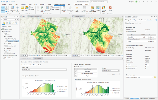
The Evaluate environment includes the Evaluate tab, the Evaluate Pane, two maps, and specific contents.
Geoprocessing tools, raster functions, and Python
- See Spatial Analyst toolbox for new and enhanced geoprocessing tools.
- See raster functions for new and enhanced raster functions.
Geoprocessing tools
3D Analyst toolbox
New tools
- Prepare Point Cloud Object Detection Training Data—Creates point cloud training data for object detection models using deep learning.
- Train Point Cloud Object Detection Model—Trains an object detection model for point clouds using deep learning.
- Detect Objects From Point Cloud Using Trained Model—Detects objects captured in a point cloud using a deep learning model.
- Extract Objects From Point Cloud—Generates 2D and 3D geometry that represents objects identified from a classified point cloud.
Enhanced tools
- Classify LAS Ground—Six optional parameters were added: Classify low-noise points, Classify high-noise points, Minimum Height Above Ground, Minimum Depth Below Ground, Preserve existing low noise, and Preserve existing high noise.
- LAS To Multipoint—Supports LAS datasets as input and adds the capability to browse to and select folders.
- Extract Power Lines From Point Cloud—Supports point cloud scene layers as input.
- Extract LAS—Supports service-based point cloud scene layers as input.
- Classify LAS By Height—The new Raster Surface ground source option allows you to use a raster dataset as a height source.
- Import 3D Files—Supports larger input files without dropping textures.
- Layer 3D To Feature Class—Supports square and rectangular profiles for strokes.
Analysis toolbox
Enhanced tools
- Spatial Join—You can use the Matching Attributes parameter to filter the spatial join results by a specified attribute field.
Aviation toolbox
Enhanced tools
- Generate Airspace Lines—Supports selection of multiple preferences.
- Generate Derived Airspace Geometry—Supports XY Tolerance environment values to prevent small gaps in geometry.
- Report Aviation Chart Changes—Now stores all values (including NULL values) in the base and comparison versions. Once the tool has been run, it no longer depends on existing versions to compare changes.
Business Analyst toolbox
Enhanced tools
- Generate Grids and Hexagons—You can output the centroids of each grid or hexagon cell as a point layer.
Cartography toolbox
New tools
- Convert Control Points To Vertices—Converts control points used for symbol effects on a feature layer to vertices.
Conversion toolbox
Point Cloud toolset
Enhanced tools:
- LAS Dataset To Raster—Supports parallel processing.
- Point Cloud To Raster—Supports service-based point cloud scene layers.
To Geodatabase toolset
New tools:
- Extract BIM File Floorplan—Extracts 2.5D floor plan data from a BIM file workspace into a geodatabase dataset.
Data Management toolbox
3D Objects toolset
New tools:
- Export 3D Objects—Exports 3D object features to one or more 3D model file formats.
- Import 3D Objects—Imports 3D features from one or more 3D file formats.
Data Loading toolset
The tools in the new Data Loading toolset allow you to streamline data loading from a source schema to a target schema.
New tools:
- Create Data Loading Workspace—Creates a Data Loading Workspace containing a collection of workbooks for schema mapping.
- Generate Mapping Table—Generates a Mapping Table based on a configured data loading workspace.
- Load Data To Preview—Uses a Data Loading Workspace to load data from a source to a preview geodatabase.
- Load Data Using Workspace—Uses the Data Reference workbook from the Data Loading Workspace to load data from a source to a target dataset.
- Update Data Loading Workspace Schema—Creates a copy of a Data Loading Workspace and updates all mapping and domain workbooks.
Features toolset
Enhanced tools:
- Points To Line—The tool was rewritten to improve performance and provide progress updating.
- XY Table To Point—You can use the Processing Extent environment to set a spatial filter that controls which records from the table are written to the output feature class.
Fields toolset
New tools:
- Migrate Date Field To High Precision—Migrates date fields in a table to high precision.
Enhanced tools:
- Calculate Field:
- Supports expressions written in VBScript, the default expression language used in ArcMap.
- Supports the ISO 8601 format when setting values for the following field types: Date, Timestamp offset, Date only and Time only.
- Calculate Fields (multiple):
- Supports expressions written in VBScript, the default expression language used in ArcMap.
- Supports the ISO 8601 format when setting values for the following field types: Date, Timestamp offset, Date only and Time only.
- Convert Temporal Field:
- The tool was relabeled from Convert Time Field.
- Supports more temporal formats including the Date only, Time only, and Timestamp offset field data types; text fields that comply with the ISO 8601 format; and time zone designators in UTC (Z) and UTC offset formats.
General toolset
New tools:
- Upload File To Portal—Uploads a file to the active portal. Supported file types are .lyrx, .mapx, .pagx, .pdf, .rptt, .rptx, and .stylx.
Geodatabase Administration toolset
New tools:
- Migrate Object ID To 64 Bit—Migrates the ObjectID field for a geodatabase table or feature class table from 32 bit to 64 bit.
Joins and Relates toolset
Enhanced tools:
- Add Join:
- You can use the Rebuild join field indexes parameter to repair broken indexes when you run the tool. This option can fix unexpected join results or ensure that incorrect indexing does not cause problems with the join.
- If the join table has a definition query, the tool indicates this with a message and specifies the number of records that will be processed.
- Add Spatial Join:
- The Matching Attributes parameter filters the spatial join results using a specified attribute field.
- The Permanently Join Fields parameter permanently adds fields from the join layer to the target layer.
Projections and Transformations toolset
New tools:
- Create Custom Vertical Transformation—Creates a transformation definition for converting data between two vertical coordinate systems or datums.
Enhanced tools:
- Project—Supports OGC GeoPackage files (.gpkg) or memory workspace datasets as input and output.
Raster toolset
New tools:
- Compute Depth Map—Computes a more accurate CenterZ field value based on the depth map for each image comprising a mosaic dataset.
- Remove Depth Map—Removes the depth map from a mosaic dataset.
Enhanced tools:
- Create Ortho Corrected Raster Dataset—Supports the Raster Analysis environment.
- Generate Block Adjustment Report—Supports JSON and brief JSON formats.
Workspace toolset
New tools:
- Generate Schema Report—Generates an Excel, JSON, PDF, or HTML representation of the geodatabase schema. See Generate a schema report in the Highlights section.
GeoAnalytics Desktop toolbox
Enhanced tools
- Aggregate Points—Supports H3 bins.
- Join Features—The Include Distance option allows you to specify whether results include the calculated spatial distance and temporal distance between joined features.
GeoAnalytics Server toolbox
Enhanced tools
- Aggregate Points—Supports H3 bins.
- Join Features—The Include Distance option allows you to specify whether results include the calculated spatial distance and temporal distance between joined features.
Geocoding toolbox
New tools
- Add Polygon Fields To Locator—Adds custom output fields from a polygon layer to an existing locator stored locally.
- Delete Polygon Fields From Locator—Deletes all polygon fields from a locator that were added using the Add Polygon Fields To Locator tool.
Enhanced tools
- Assign Zones To Streets—The tool was moved to the Data Preparation toolset.
- Create Feature Locator—A Custom Output Fields parameter was added. Additionally, the tool now supports building locators with z-aware point data.
- Create Locator—Locators for South Africa can be created. Additionally, the tool now supports building locators with z-aware point data.
- Geocode Addresses—Now returns results with z-values from locators that use z-aware reference data.
- Split Address Into Components—The tool was moved to the Data Preparation toolset. Additionally, the Country or Region parameter now supports Czechia (CZE), Spain (EST), Italy (ITA), Lithuania (LTU), Latvia (LVA), Puerto Rico (PRI), Sweden (SWE), and South Africa (ZAF).
Geostatistical Analyst toolbox
New tools
- IDW 3D—Interpolates the values of 3D points using inverse distance weighting (IDW) and creates a voxel layer of the predicted values.
Enhanced tools
- Nearest Neighbor 3D and GA Layer 3D To NetCDF—A voxel layer of the output netCDF file is automatically added to an open scene with custom elevation settings and symbology. The voxel layer is also saved as a derived output for automated workflows.
Image Analyst toolbox
- The new Interpolation toolset was added to the Image Analyst toolbox. It contains the Optimal Interpolation and Interpolate From Spatiotemporal Points tools.
New tools
- Optimal Interpolation—Statistically assimilates data combined from multiple sources to produce an output raster.
- Compute SAR Indices—Computes various SAR indices, such as Radar Vegetation Index (RVI), Radar Forest Degradation Index (RFDI), and Canopy Structure Index (CSI).
- Detect Bright Ocean Objects—Detects potential bright human-made objects, such as ships, oil rigs, and windmills, while masking out the SAR data outside the region of interest.
- Detect Dark Ocean Areas—Detects potential dark pixel clusters, such as oil spills and algae, while masking out the SAR data outside the region of interest.
- Multilook—Averages the input SAR data by looks in range and azimuth to approximate square pixels, mitigate despeckle, and reduce SAR tool processing time.
- Create Binary Mask—Converts an input raster dataset to a binary raster. Pixels are labeled as either mask or background based on user-defined values.
Enhanced tools
- Classify Pixels Using Deep Learning—The new Overwrite attachments parameter allows you to overwrite the existing feature class or create a new feature class to store new attachments.
- Interpolate From Spatiotemporal Points—The tool was moved from the Multidimensional toolset to the Interpolation toolset. Additionally, the Interpolation Method parameter has a new Median option.
- Train Deep Learning Model—The tool user interface was redesigned to place the Pre-trained Model parameter near the top of the tool. The following new parameters were added:
- Data Augmentation
- Augmentation Parameters
- Chip Size
- Monitor Metric
- Resize To
- Weight Initialization Scheme
- Zonal Statistics—The following options were added to the Statistics Type parameter: Majority percentage, Majority count, Minority count, and Minority percentage.
- Zonal Statistics as Table—The following options were added to the Statistics Type parameter: Majority count; Majority percentage; Majority value, count, and percentage; Minority count; Minority percentage; and Minority value, count, and percentage.
Indoor Positioning toolbox
New tools
- Generate Indoor Positioning File Without Survey—Generates a positioning file from beacon and floor plan data by simulating Bluetooth signal propagation through the indoor environment.
Indoors toolbox
New tools
- Import CAD To Indoor Dataset—Imports CAD data to the ArcGIS Indoors Information Model.
- Import IFC to Indoor Dataset—Imports IFC data to the ArcGIS Indoors Information Model.
- Upgrade Indoors Database—Updates an existing Indoors workspace to the latest version of the ArcGIS Indoors Information Model schema.
Location Referencing toolbox
New tools
- Reverse Line Orders—Supports reversing the line orders for all routes on a line across all time. The tool is designed to support a scenario in which routes are misloaded or produce derived network routes in the incorrect direction.
Enhanced tools
- Append Routes:
- Curves are auto-densified if the input feature class has curves within it.
- You can specify the field for loading routes with the new Load Field parameter.
- Supports checking line order values.
- Supports loading using the Route Name or Route ID field when the field is configured for the network/event.
- Append Events—Supports loading using the Route Name or Route ID field when the field is configured for the network/event.
- Generate Routes—Automatic calibration logic replaced the Record calibration changes for event location updates parameter.
Maritime toolbox
- The new Data Management toolset toolset was added to the Maritime toolbox. It contains the Expand Collapsed Contours, Generate Depth Areas, Generate Land Areas, Reduce Point Density, and Smooth Bathymetric TIN tools.
New tools
- Expand Collapsed Contours—Expands (pulls apart) contour lines that are snapped together. This preserves representative depth areas.
Enhanced tools
- Import S-100 Feature Catalogue:
- The Coordinate System parameter specifies the coordinate system of the output workspace.
- The Subtype Mapping File parameter specifies the feature classes within which each S-100 feature will be subtyped.
- The Configuration Keyword parameter can be used to determine the storage parameters of the database table for enterprise geodatabases.
- Several environments were added.
- Repair Nautical Data—A Nudge Boundary Features option was added to the available repair processes.
Multidimension toolbox
New tools
- Make Multidimensional Voxel Layer—Creates a voxel layer from a multidimensional voxel dataset.
Oriented Imagery toolbox
- The Oriented Imagery toolbox is a new toolbox containing tools to create, manage, and maintain oriented imagery datasets and layers. The tools allow you to create oriented imagery datasets, which are used to manage collections of oriented images (including oblique drone imagery, close-range inspection images, and street-level images taken by mobile devices).
New tools
- Add Images To Oriented Imagery Dataset—Adds images to an oriented imagery dataset from multiple input sources, including a file, folder, table, list of image paths, or point feature layer.
- Build Oriented Imagery Footprint—Builds a footprint feature class for an oriented imagery dataset.
- Create Oriented Imagery Dataset—Creates an empty oriented imagery dataset in a geodatabase.
- Update Oriented Imagery Dataset Properties—Updates or modifies oriented imagery dataset properties.
Parcels toolbox
New tools
- Create Parcel Seeds—Creates parcel seeds for closed loops of lines that are associated with the specified parcel record.
- Delete Parcels—Deletes the selected parcels from the input parcel fabric. If the parcel polygon layer has no selection, all parcels are deleted.
- Export Parcel Record Features—Exports the parcel features associated with a selected parcel record to individual feature classes.
Enhanced tools
- Copy Parcels—Related tables, attachments, and feature-linked annotation are also copied to the target feature dataset.
Public Transit toolbox
Enhanced tools
- Calculate Transit Service Frequency—New parameters allow you to model traveling with a wheelchair and traveling with a bicycle, and to exclude certain modes of public transit from the analysis.
Reality Mapping toolbox
New tools
- Compute Depth Map—Computes a more accurate CenterZ field value based on the depth map for each image comprising a mosaic dataset.
- Remove Depth Map—Removes the depth map from a mosaic dataset.
Enhanced tools
- The tools now support standard satellite data.
- Reconstruct Surface—Certain parameter options were deprecated. See the deprecation note in the tool help for details.
- Generate Block Adjustment Report—Supports JSON and brief JSON formats.
Server toolbox
New tools
- Get Report Templates Info—Returns the content of report files and templates in JSON format.
Enhanced tools
- Export Web Map— New parameters support generating reports for server-side printing workflows.
Spatial Analyst toolbox
New tools
- Feature Solar Radiation—Calculates the incoming solar insolation for input points or polygon features relative to the surface (ground) on the earth or moon.
- Optimal Corridor Connections—Calculates the optimal corridor connections between two or more input regions.
- Raster Solar Radiation—Calculates the total solar insolation for every raster cell of a digital surface model for the earth or moon.
- Space Time Kernel Density—Expands kernel density calculations from analyzing the relative position and magnitude of the input features to include other dimensions such as time and depth (elevation). The resulting output identifies the magnitude-per-unit area using the multiple kernel functions to fit a smoothly tapered surface to each input point.
Enhanced tools
- Locate Regions—The default value of the nonallocated region changed from 0 to NoData.
- Zonal Statistics——The following options were added to the Statistics Type parameter: Majority percentage, Majority count, Minority count, and Minority percentage.
- Zonal Statistics as Table—The following options were added to the Statistics Type parameter: Majority count; Majority percentage; Majority value, count, and percentage; Minority count; Minority percentage; and Minority value, count, and percentage.
Spatial Statistics toolbox
New tools
- Causal Inference Analysis—Estimates the causal effect of a continuous exposure variable on a continuous outcome variable by approximating a randomized experiment and controlling for confounding variables. The tool can be used to model causal relationships from data collected in an observational study.
- Convert Spatial Statistics Popup Charts for Web Display—Prepares interactive pop-up charts for web display by saving them as image attachments to a feature class. You can share the output as a web service to ArcGIS Online, and the charts will appear in the pop-ups of the web feature layer.
Enhanced tools
- Forest-based and Boosted Classification and Regression—The Gradient Boosted option of the Model Type parameter uses a variant of the Extreme Gradient Boosting (XGBoost) algorithm to perform the classification or regression. Various tuning parameters can be optimized to improve the accuracy of the model. Previously, the tool label was Forest-based Classification and Regression.
Topographic Production toolbox
New tools
- Set Line Direction—Sets the direction of a line segment to match the slope direction of elevation features.
Enhanced tools
- Calculate Metrics—The new Elevation Raster parameter allows you to use a raster file to derive elevation metrics.
- Generate Location Diagram Features—The new Specification parameter allows you to specify a map product. If you specify an Operational Navigation Chart (ONC) or Tactical Pilotage Chart (TPC) map product, you can also define a smoothing tolerance and hydrology settings.
- Validate Spot Heights—The tool can be run without using the elevation raster specified in the Input Rasters parameter.
Utility Network toolbox
Enhanced tools
- Validate Network Topology—The new Output JSON derived output parameter returns the name of any subnetwork that is marked as dirty along with its domain network and tier in the output. A trace is used during validation to discover which subnetworks were modified. The output JSON for these subnetworks can be copied from the Messages tab of the tool's View Details window.
- Trace—When performing an isolation trace with the Include Isolated Features parameter checked, the Include Barrier Features parameter is now available and enabled by default. This allows you to include or exclude the isolating barrier features in the trace result.
ArcGIS Reality for ArcGIS Pro
- Satellite data is now supported in Reality for ArcGIS Pro tools and workflows.
- When performing a block adjustment, full frame stereo pairwise matching is supported for the Recompute Tie Points tool
 .
. - Support was added for processing imagery data stored in the Azure or AWS cloud platforms.
Geoprocessing tools
- See Reality Mapping toolbox for new and enhanced geoprocessing tools.
Data management and workflows
BIM
- See the To Geodatabase toolset in the Conversion toolbox for new and enhanced geoprocessing tools.
CAD
- CAD data organization has been simplified in the Contents pane.
- The symbology of CAD text has been enhanced using more CAD line types, line weight, and better RGB color matching. Performance has been significantly improved.
- CAD features now honor entity color in addition to layer color when displayed.
- Layer organization buttons have been added to the layer category of the CAD Data contextual ribbon tab.
- Text entities from CAD files in a CAD dataset are now represented as annotation features in an annotation feature class. A labeled point feature class named TextPoints is also included to support legacy workflows that use labeled points as text features.
- Support was added for AutoCAD Civil 3D surface right of way, boundaries, grading entities, and surface points as features.
Data Reviewer
The following enhancements were made to the ArcGIS Data Reviewer checks:
- The Find Polygons with Holes check has been added. This check finds holes in polygon features that should not contain holes.
- In the Find Event Gaps check, you can filter the number of routes for evaluation as well as configure feature results by time.
- The Monotonicity check supports multipart and gapped routes.
- Constraint rules are supported in the Unnecessary Nodes and Unnecessary Polygon Boundaries checks.
Visual review tools have been added that are different from the Reviewer workspace-based visual review tools. These new tools do not require a Reviewer workspace and use attribute rule error tables. They are currently available for file and mobile geodatabases. The following tools have been added:
- The Browse Features tool allows you to identify errors on existing features.
- The Flag Missing Features tool allows you to identify missing features.
Geocoding
- Return collections is a new suggest property for POI role locators that allows you to enable or disable collections (POI categories) from being included in suggestions. This property is supported for locators shared to ArcGIS Enterprise 11.2 or published to ArcGIS Server 11.2.
- Locators have a new match option property, Comprehensive zone matching, that allows addresses to match to cities that do not exactly match the input city name.
- Portal users without administrative privileges can create and persist locator views in an ArcGIS Pro project. Locator views are versions of a geocoding service with settings and preferences applied. They can be based on a geocode service from an ArcGIS Server connection, a geocoding utility service from a portal, or a locator item stored in the portal.
- The Category and Country parameters in batch geocoding are now supported for local composite locators and composite geocoding services.
- The rematch cache can be imported or exported to improve sharing cached matches across an organization.
- The Split Address Review pane supports checking for similar addresses and batch updating split patterns when you review the results of the Split Address Into Components geoprocessing tool.
Geoprocessing tools and Python
- See Geocoding toolbox for new and enhanced geoprocessing tools.
- See Geocoding module in the Python section for Geocoding module enhancements.
Geodatabases and databases
Note:
New field data types are supported in geodatabases, databases, cloud data warehouses, and text files. Existing query layers or text files may contain field data types that ArcGIS Pro 3.2 interprets as one of the new data types. To publish web layers from these query layers, or to run scripts that access these text files, you may need to configure ArcGIS Pro to use data types compatible with ArcGIS Pro 3.1 and earlier releases.
- You can generate a data dictionary style report of your geodatabase schema in multiple formats (JSON, Excel, HTML, and PDF). See Generate a schema report in the Highlights section.
- The new Big integer, Date only, Time only, and Timestamp offset field data types are supported in tables and feature classes in file geodatabases, mobile geodatabases, and most databases and 11.2.0 enterprise geodatabases when you work with the data from the Databases connection
 in the Catalog pane or a catalog view. See which data types are supported by each database platform.
 - You can migrate Object ID fields in geodatabase tables and feature classes to store values larger than 32-bit values. This is useful for tables or feature classes that need to store more than 2.14 billion records.
- You can migrate Date fields in a table or feature class in a geodatabase to high precision, allowing them to support time with millisecond values.
- When you work with the Fields view or Domains view of an attribute table, you can click Refresh
 on the ribbon to update the view with the current state of the dataset and workspace.
Cloud data warehouses
- The new Big integer, Date only, Time only, and Timestamp offset field data types are supported when you connect to a cloud data warehouse in ArcGIS Pro to view and query data. See which data types are supported by each cloud data warehouse platform.
- Date fields in query layers that access cloud data warehouse tables automatically display high precision values if they are present. To use these values without high precision, you can configure ArcGIS Pro to use field data types compatible with ArcGIS Pro 3.1 and earlier releases.
- Additional connection options are now available when you create a database connection to a cloud data warehouse.
- You can publish a read-only web feature layer from data in Amazon Redshift.
Enterprise geodatabases and databases
- The redesigned Database Connection dialog box has two tabs:
- Connection Properties—Includes properties required to connect to a relational database management system or cloud data warehouse. New context-sensitive options are specific to the database or cloud data warehouse type.
- Geodatabase Connection Properties—Allows you to access versioning and historical moment settings when you connect to an enterprise geodatabase. Previously, these properties were only accessible from the context menu of an existing connection.
- Support for PostgreSQL 15.4 was added.
- Security Support Provider Interface (SSPI) or Lightweight Directory Access Protocol (LDAP) logins can now be used for the sde user in newly created geodatabases in PostgreSQL.
- Generic Security Service Application Program Interface (GSSAPI) logins can be used for nonadministrator connections to PostgreSQL.
- Support for SpatiaLite 5.0.1 with SQLite databases used with ArcGIS was added.
- Query layers containing Date fields automatically display high precision values if they are present. To use these values without high precision, you can configure ArcGIS Pro to use field data types compatible with ArcGIS Pro 3.1 and earlier releases.
Mobile geodatabases
- The Compact geoprocessing tool now works on mobile geodatabases to rearrange data storage and reduce file size.
Text files
The new Big integer, Date only, Time only, and Timestamp offset field data types are supported when you add an ASCII file or text file to ArcGIS Pro and view or query data.
Indoors
- New fields have been added to the Reservations feature class schema to support recurring office hotel bookings in Indoor Viewer and Indoors mobile.
ArcGIS Knowledge
- You can document sources of the information stored in the knowledge graph by adding provenance records. This is an optional capability that can be enabled when you create a knowledge graph.
- In an appropriately configured ArcGIS Enterprise 11.2 deployment, you can create a new investigation and knowledge graph using an ArangoDB database as a NoSQL data store. Only ArcGIS-managed data can be stored in the NoSQL database.
- When you define new entity types and relationship types in a knowledge graph, Unicode characters can be used in the type names with some restrictions.
- When adding properties to an entity or a relationship, the following field data types are supported as beta functionality when you edit a knowledge graph from an ArcGIS Enterprise 11.2 deployment: Big integer, Date only, Time only, and Timestamp offset.
- When you work with a knowledge graph in a link chart, a radial menu is available using the keyboard shortcut Alt+R. The radial menu provides keyboard access to operations such as exploring and editing entities and relationships and their properties.
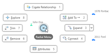
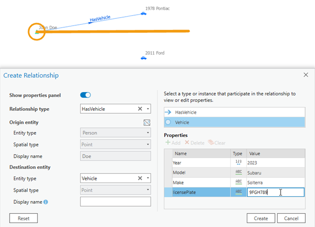
- The Create Relationship editing tool is available from the radial menu to define a relationship and its properties in one step.
- When you use the Filtered Find Paths pane to explore connections between entities in a link chart, new options are available to specify the path's direction and to indicate whether a waypoint is mandatory or optional. You can save your configurations for this pane as part of the investigation.
Services
- OGC API Tiles (map tiles) layers are now displayed in the contents of an OGC API server connection. You can add these layers to a map and view the layer properties.
Workflow Manager
- You can review, edit, and add informal information to your jobs using the Notes tab.
- You can now manage all job property types in the Workflow pane.
- One-to-many properties can now be viewed and managed in the Workflow pane.
- You can use the Open Pro Project Items step to open, sync, and edit replica layers offline in ArcGIS Pro.
- You can use the Workflow Client namespace in the ArcGIS Pro SDK 3.2 for .NET to retrieve connection information and job IDs.
Editing
General
- You can set edit session options to require manual enabling of tools and to specify how workspaces are managed. See Choose and edit a single workspace in the Highlights section.
- A new editing application option allows nonplanar geometry to be created when merging overlapping z-aware polygons with edges at different elevations.
- In the Modify Features pane, with the Edit Vertices tool
 active, vertices for parts of multipart features are numbered separately. Each part begins with the number one.
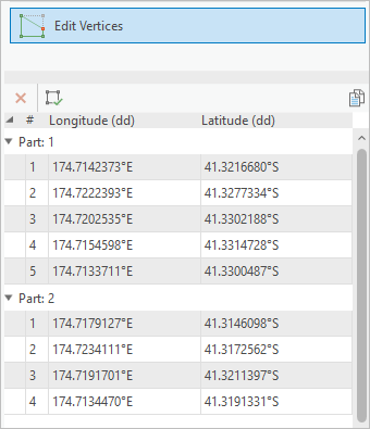
- You can set the origin vertex in the sequence of vertices that form a polygon boundary or part.
- You can copy coordinate values to the clipboard when you edit vertices or feature attributes.
- You can reverse the direction of a traverse course by right-clicking the course in the traverse grid and clicking Reverse Direction.
Parcel fabric
- Parcel fabric web feature layers can be taken offline and edited without a network connection. Parcel fabrics must be published as a sync-enabled, editable feature service and must be added to a web map that is configured for offline use.
- You can configure which record attributes are displayed for records returned from search queries in the Manage Records pane.
- The Set Current
 and Set Historic
  commands can be used to set individual points and lines as current or historic.
 - The Align Parcels tool
 was enhanced. Vertices that were collinear with parcel points before alignment remain collinear after alignment.
 - Parcel lines that use geodetic line templates can be analyzed and adjusted using the Analyze Parcels By Least Squares Adjustment geoprocessing tool.
- You can explode multipart parcels in the parcel fabric in a record-driven workflow.
- Gaps and overlaps can be highlighted between all visible parcel layers in the map. You can also highlight only gaps or only overlaps.
- Parcel lineage for a record in the parcel fabric can be displayed using link charts.
Imagery and remote sensing
Imagery and raster charts
- Surface profile—Surface profile charts allow you to visualize change in raster values, such as elevation or surface temperature, over distance.
- Trajectory profile—A trajectory profile chart allows you to visualize the variable changes of a trajectory layer. You can visualize and compare variables along one track or compare a variable between multiple tracks.
Oriented imagery
- You can use oriented imagery to manage collections of oriented images, including oblique drone imagery, close-range inspection images, and street-level images taken by mobile devices. See Oriented imagery in the Highlights section.
- You can add an oriented imagery dataset or oriented imagery feature service to a map as an oriented imagery layer with an optional footprint layer. The oriented imagery layer is an extended point feature layer in which each point represents the location where an image was acquired. The point's attributes include the path to where the image is stored and key metadata required to visualize the image in the Oriented Imagery Viewer.
Use the Oriented Imagery Viewer pane and the Oriented Imagery Layer ribbon tab to visualize and explore images managed as oriented imagery layers in a map.
Ortho mapping
- When performing a block adjustment, full frame stereo pairwise matching is supported for the Recompute Tie Points tool
 .
. - Ortho mapping supports several new data formats, including Esri Frame XML, Generic RPC, GORI, BlackSky, Pleiades Neo Tri-Stereo (Enhanced), Raster Dataset, and ADS.
- Processing imagery data stored in Azure or AWS cloud is supported.
Raster data types and sensors
- Support was added for Zarr, a cloud-based data format that provides improved access to multidimensional data. Zarr variables are supported as raster datasets, which you can browse in the Catalog pane, use in analysis, and publish as image services. See the complete list of supported raster file formats.
- Four new trajectory data types are supported: Jason-2, Jason 3, ICESat-1, and GEDI.
SpatioTemporal Asset Catalog (STAC)
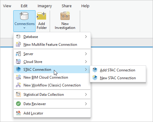
- You can access items and collections in different cloud stores through a SpatioTemporal Asset Catalog (STAC) connection. The connection provides an interface to search collections, locate datasets, and use them in ArcGIS Pro.
Geoprocessing tools and raster functions
- See Oriented Imagery toolbox for new oriented imagery geoprocessing tools.
- See Reality Mapping toolbox for new and enhanced ArcGIS Reality for ArcGIS Pro geoprocessing tools.
- See Raster toolset in the Data Management toolbox for new and enhanced raster geoprocessing tools.
- See Raster functions for new and enhanced raster functions.
Mapping and visualization
General
- A drawing alert notification system has been added to maps, scenes, link charts, and other project items.
- You can set the behavior of group layers to draw one sublayer at a time (radio type) or with traditional individually controlled sublayer visibility (check box type).
- You can use the Apply button to apply map and layer properties iteratively and see your changes without closing the respective properties dialog boxes.
- You can copy and paste the properties of one layer or table to another in feature layers, stand-alone tables, and subtype group sublayers.
- You can clear the selection of individual layers from the Selection tab of the Contents pane.
- In a map image layer, you can open and view the attribute table of its sublayers, view attribute information and relationships in pop-ups, and export all or a subset of features as a table.
- An option to preserve field type compatibility with ArcGIS Pro 3.1 and earlier releases for query layers and text files is available.
- System administrators who manage application settings can set options for default table appearance and to show crosshairs when flashing a clicked location.
- A new rendering engine option, DirectX 12, is available.
3D scenes and scene layers
- You can use 3D basemaps when your active portal is set to ArcGIS Online. See 3D basemaps in the Highlights section.
- A new layer type, 3D tiles, is available to visualize 3D object and mesh 3D tiles datasets.
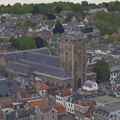
A 3D tiles layer added to a scene as an integrated mesh. - You can enable time and range properties on elevation source layers.
- New elevation context menu options on raster and TIN layers allow you to duplicate the layers in the ground or create custom elevation surface layers.
- You can view unique value counts for voxel layers in the Symbology pane.
- Improved display caching for elevation surfaces provides better performance when returning to previously visited areas.
- Shadows and ambient occlusion in 3D scenes have improved quality near the camera, and higher performance overall.
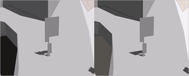
ArcGIS Pro 3.2, shown on the right, has made improvements to shadow map resolution as well as contrast adjustments to shadows and ambient occlusion. - You can multiselect layers in the Contents pane and update the elevation mode.
- You can enable time on individual category layers in a building scene layer.
- A new Relative to the scene elevation type aligns feature layers to objects in a 3D scene.
Annotation and labeling
- The Labeling Summary report lists the fonts used by label classes and identifies any that need to be installed.
- You can use the Maplex Label Engine Avoid overlapping labeled polygons as if holes parameter to place labels using the remaining space in a polygon when there is an overlapping feature.
- The Measure along clipped feature geometry and Place label using clipped feature geometry parameters in the Maplex Label Engine place line and polygon labels using clipped feature geometry.
- Abbreviation dictionaries perform case-sensitive matches before matches that are not case sensitive.
- 64-bit object IDs are supported with feature-linked annotation.
- The Upgrade Dataset tool supports all ArcGIS Desktop annotation versions.
Arcade
- ArcGIS Pro 3.2 supports Arcade 1.24. For a summary of new features, see the Arcade Release notes for versions later than 1.23.
Catalog layers
- Attribute field nomenclature now aligns with the portal item information model. This change impacts catalog layers created in ArcGIS Pro 3.1.
Coordinate systems and transformations
- When choosing a coordinate system, you can filter the list of coordinate systems by the underlying geographic coordinate system, projection property, and spatial extent.
- You can organize your favorite coordinate systems in operating system folders to show them in headings in the Coordinate Systems Available list.
- New vertical transformations based on geoids, quasi-geoids, or other conversion grids can transform to or between gravity-related vertical coordinate systems for Austria, Canada, Denmark, Faroe Islands, French Antilles, Germany, Greenland, Iceland, Norway, Papua New Guinea, Poland, Slovenia, South Africa, Spain, and Sweden.
- When you create a gravity-related vertical coordinate system, you can specify a custom vertical datum.
- You can specify a name for custom datums and spheroids when defining a new geographic coordinate system, a new projected coordinate system, or a new ellipsoidal-based vertical coordinate system.
- You can set an unknown coordinate system for a map when necessary for troubleshooting.
Exploratory analysis tools
- The Object Detection tool has added the Esri Generic Object detection model, which allows you to click in the map or scene to detect objects from the imagery. The model is provided by default and does not need to be downloaded.
Layouts
- With a thematic map series, you can create a page for each layer (or group of layers) as specified in a radio group layer. See Thematic map series in the Highlights section.
- Table frames include an option to balance columns in a table frame field to make them approximately the same length.
- Legends include a right to left option which reverses the flow of a legend to optimize it for right-to-left reading languages.
- A new statistic, Distinct Count, is available for dynamic text to return the number of distinct values in the field selected.
- Distinct Values is table dynamic text that returns only distinct values from an attribute or stand-alone table field.
- Value is table dynamic text that supports sorting results by a field in the table. If no sorting option is chosen, the data displays in the order created.
Pop-ups
- Fields elements consider the list of permissible URL schemes and file extensions when recognizing links. These are defined on the Security tab of the project options.
- Carousel elements support a title and caption when you configure pop-ups.
Print and export maps and layouts
- You can export a map series to JPEG, PNG, and TIFF file formats in addition to PDF. When you export to JPEG, PNG, or TIFF, a file is created for each page in the series.
- A TrueType font is created from variable fonts embedded in vector exports. This maintains hinting and smoothing when the output is viewed in PDF or AIX formats.
- You can remove the page background when exporting a layout as a PDF file.
- You can preview printer margins and tiling lines on the layout view when printing a layout.
Range
- You can set a range property for a layer to make the range slider step to the next unique data value even when values are irregularly spaced.
Reports
- You can create report templates to simplify the report authoring process.
- The Details subsection of a report can expand when dynamic text contains more characters than can fit in the designated space.
- Supplemental pages can directly follow a report instead of starting on a new page.
Styles
- You can save all items in a project to a style. See Save items to a style in the Highlights section.
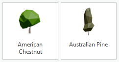
- A system style called 3D Vegetation - Low Poly containing 3D point symbols with low polygon counts of various species of plants was added. These symbols are low poly versions of the same tree species represented in the 3D Vegetation - Realistic and 3D Vegetation - Thematic system styles. They provide similar drawing performance metrics compared to the thematic trees while more closely resembling the appearance of the realistic trees. See 2D thumbnails of the symbols in this
style in the 3D Vegetation - Low Poly PDF guide.
- Two 3D line symbols that use the new square and rectangular stroke profiles were added to the ArcGIS 3D style.
- Two discrete qualitative color schemes were added to the ArcGIS Colors style to support network analysis.

Symbols
- The Format Symbol pane includes a toggle button to apply symbol edits as you make them.
- You can view the feature count for special values, such as out of range or excluded values, in the Symbology pane even if the classes are not present in the legend.
- When symbolizing polygons with proportional or graduated symbol symbology, you can control whether the symbols draw above other layers in the map, or with their layer in the draw order of the map. Similarly, you can control this draw order for chart symbols when symbolizing line or polygon layers.
- In heat map symbology, when the rendering method is constant, you can lock the radius at a specified scale to emulate a reference scale and prevent regeneration as you pan and zoom around the map.
- Square and rectangular profiles are available for stroke symbol layers used in a 3D context.
- You can adjust the patch size of point symbols in the Contents pane to accommodate larger symbols.
- A trapezium patch shape can be specified for polygon symbol classes.

Tables
- You can change the default table appearance, including the text font and size and the row and column header heights. You can override the row and column heights for an active table.
- You can honor selection color overrides set on the layer or the project.
- The supported URI schemes and file extensions that determine a valid hyperlink have moved in the project options from the Table tab to the Security tab and now also control hyperlink validity in pop-ups.
Time
- Time-aware layers support the new Date only and Timestamp offset field data types. See New field data types in the Highlights section.
Vector tiles
Vector tiles can be added from styles referencing TileJSON sources or from TileJSON itself by adding data from a path to a map. When you add a layer from TileJSON itself, the vector_layers array is used to define layers to draw with default symbols and their defined scales.
Production
Aviation Charting
- See Aviation toolbox for new and enhanced geoprocessing tools.
Bathymetry
Note:
The ArcGIS Bathymetry extension for ArcGIS Pro was introduced at version 3.1. The data installer included the following tools in the Bathymetry toolbox:
- Create BIS—Creates a Bathymetric Information System (BIS) in a designated geodatabase workspace.
- Add Data To BIS—Registers raster and feature class data to a Bathymetric Information System (BIS).
- BIS To Mosaic Dataset—Creates a mosaic dataset from a Bathymetric Information System (BIS).
A Bathymetric Information System created at version 3.1 is not compatible with Bathymetry tools at version 3.2. A new BIS must be created with the Create BIS tool to use with the tools at version 3.2.
- You can use the Explore Bathymetry tool
 on the Bathymetry tab to filter bathymetric data in a BIS.
 - You can use the Compose Surface tool
 on the Bathymetry tab to sort and visualize bathymetric data in a BIS.
Bathymetry geoprocessing tools
New tools:
- Add Point Cloud To BIS—This tool registers point cloud (LAS or LASD) data to a Bathymetric Information System (BIS).
Enhanced tools:
- Create BIS—A Proxy Raster Location parameter was added to specify a location for storing proxy raster tools. A new workflow for creating a BIS was also introduced.
- Add Data To BIS—An Update Overviews parameter was added to specify whether overviews and statistics for a mosaic dataset are calculated and updated.
Defense Mapping
The ArcGIS Defense Mapping product data files were enhanced in several ways, including the following:
- Rule files were added to generalize Topographic Data Store (TDS) data from a 1:250,000 scale to scales of 1:500,000 and 1:1,000,000. This supports Tactical Pilotage Chart (TPC) and Operational Navigation Chart (ONC) cartographic production.
- Automation was enhanced for the adjoining sheets guide of the Topographic Map (TM) and Multinational Geospatial Co-production Program (MGCP) Topographic Map (MTM) that are created with the Generate Product Layout geoprocessing tool.
- The boundaries diagram on layout templates sources the boundary data from the basemap dataset.
Geoprocessing tools
- See Topographic Production toolbox for new and enhanced geoprocessing tools.
Maritime
- The Depth Processing toolbox contains the TIN to Depth Contours tool, which chains multiple geoprocessing tools together to automate contour creation and address common topological issues. The toolbox is available in the ArcGIS Maritime product files at \ArcGIS Maritime\Product Files\<version>\Workflow\Tools.
- The Paper Charting toolbox is available in the ArcGIS Maritime data installer at <installation location>\ArcGIS Maritime\Product Files\<version>\Charting\Tools. It contains the following scripts and tools that provide a preconfigured workflow for creating nautical charts:
- Chart Automation—This script tool uses scripts, S-57 ENC data attributes, and predefined configuration to increase paper chart production efficiency.
- Make and Apply Masks from Rules—This model tool creates and applies feature polygon masks based on color rules.
- MaritimeMaskingRules.xml is a preconfigured file to use with the Make and Apply Masks from Rules model. It is available in the ArcGIS Maritime data installer in the Rules folder.
- Support was added for PostgreSQL database management.
- The S-101 data model can now be a flat or subtyped data model.
Military Symbology Editor
- You can import an existing military symbology overlay using the Military Symbology Editor.
Pipeline Referencing
- Attribute sets configured in an enterprise geodatabase can be stored in a map.
- When a map that contains an attribute set is published as a feature service, the attribute set can be used directly in ArcGIS Pro and ArcGIS Event Editor. It is not necessary to reconfigure it within the application or to import or export a .rhas file.
- When creating routes, you can copy attributes from an existing route with the Copy attribute values using route from map button
 . This button is available in the Create Route, Reassign Route, and Realign Route panes.
 - You can densify centerlines with curves into polylines to preserve shape and to build routes within an LRS Network.
- A Location Offset method has been added to the Replace Events pane.
- With the Unified Pipeline Tools add-in, you can access commonly used Pipeline Referencing and Utility Network tools on one ribbon tab. The Unified Pipeline Tools tab brings together common tools used in location referencing, utility network, and editing workflows.
- When editing a line network, you can reassign routes to a new route with the Reassign tool. In addition, you can select which type of reassignment is completed (merging to an adjacent route, forming a new route, or transferring to another line).
- The Flip the direction of the centerlines button
 allows you to flip the direction of centerlines in memory as part of the route editing operation instead of permanently flipping the geometry. This ensures that the utility network remains validated in a combined Pipeline Referencing-Utility Network environment.
 - You can merge coincident events when making edits with the Dynamic Segmentation tool.
Geoprocessing tools
- See Location Referencing toolbox for new and enhanced geoprocessing tools.
Production Mapping
The ArcGIS Production Mapping product data files were enhanced in several ways, including the following:
- A tool is available to help document the generalization rules spreadsheet in a Microsoft Word template.
- An extended property helps ensure that the same machine used to start a generalization job is used to restart, cancel, or continue the job if it is interrupted by an error.
- The performance of the Roads model has been improved.
Geoprocessing tools
- See Topographic Production toolbox for new and enhanced geoprocessing tools.
Roads and Highways
- Attribute sets configured in an enterprise geodatabase can be stored in a map.
- When a map that contains an attribute set is published as a feature service, the attribute set can be used directly in ArcGIS Pro and ArcGIS Event Editor. It is not necessary to reconfigure it within the application or to import or export a .rhas file.
- When creating routes, you can copy attributes from an existing route with the Copy attribute values using route from map button
 . This button is available in the Create Route, Reassign, and Realign panes.
 - You can densify centerlines with curves into polylines to preserve shape and to build routes within an LRS Network.
- A Location Offset method has been added to the Replace Events pane.
- When editing a line network, you can reassign routes to a new route with the Reassign tool. In addition, you can select which type of reassignment is completed (merging to an adjacent route, forming a new route, or transferring to another line).
- The Flip the direction of the centerlines button
 allows you to flip the direction of centerlines in memory as part of the route editing operation instead of permanently flipping the geometry. This ensures that the utility network remains validated in a combined Pipeline Referencing-Utility Network environment.
 - You can merge coincident events when making edits with the Dynamic Segmentation tool.
Geoprocessing tools
- See Location Referencing toolbox for new and enhanced geoprocessing tools.
Projects
General
- You can access Windows folder shortcuts in the Catalog pane, catalog views, and browse dialog boxes.
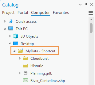
- File, mobile, and enterprise geodatabases display feature class geometry as a property in catalog views and browse dialog boxes. Other items with shape geometry, such as shapefiles and CAD files, also display their geometry type.
- You can filter search results for project items by modification date and item type.
- Search results for portal items can be spatially filtered by the extent of a map or scene in your project, by an ArcGIS World Geocoding Service location, or by a region you select. The region filter is available only for ArcGIS Living Atlas items.
- You can quickly make copies of maps, layouts, and reports with the Duplicate command
 .
. - A new catalog browsing option has been added. When you browse to an item in a catalog view, the Contents pane can expand to the location.
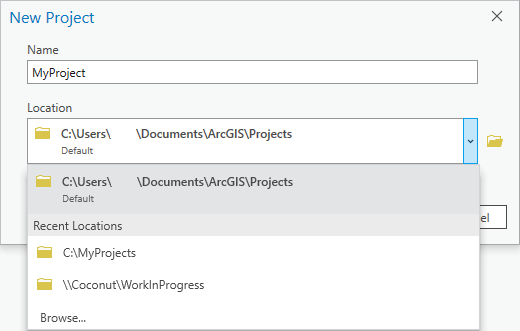
- The New Project dialog box (formerly Create a New Project) has a drop-down list of nondefault locations in which recent projects have been saved. You can select a location from the list to save a new project there.
- Badges for portal items and groups are displayed in catalog views, browse dialog boxes, and item pop-ups in the Catalog pane.
- When you use drag and drop to copy or move items, target locations expand to show their contents.
- ArcGIS Pro now supports configuring OAuth-based authentication connections with external authentication providers. When signed in, you can use authentication connections to connect to cloud stores.
- You can now update data sources for a web feature layer from a catalog view.
- System administrators who manage application settings can set and lock default authentication connections as well as settings for search indexes created by administrators.
Indexing
- The user interface for working with search indexes was redesigned and includes the following new options:
- Use indexes created and managed by a system administrator.
- Index locations that have not been added to projects.
- Exclude locations from indexing.
- Start and stop indexing manually.
- Customize indexing task schedules.
Share your work
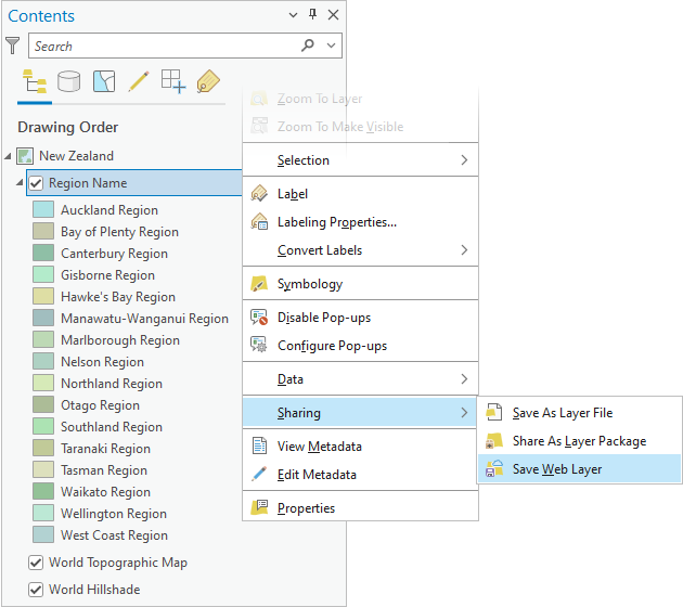
- You can use Save Web Layer
 to update the appearance of existing web feature layers in your ArcGIS organization.
- You can now add files to ArcGIS Online or ArcGIS Enterprise using the Upload File To Portal geoprocessing tool.
- You can now share web tile layers, vector tile layers, web scene layers, and web elevation layers that reference cache datasets in folders or cloud stores to ArcGIS Enterprise 11.0 or later.
- You can share catalog layers as the following web layer types:
- Web feature layer that copies all data to ArcGIS Online and ArcGIS Enterprise 11.0 or later
- Map image layer and web feature layer to ArcGIS Enterprise 11.2 or later
- You can share oriented imagery layers as the following web layer types:
- Web feature layer to ArcGIS Online
- Map image layer and web feature layer to ArcGIS Enterprise 11.2 or later
- You can publish data in Amazon Redshift as a web feature layer to ArcGIS Enterprise 11.2 or later.
- You can save service definitions that overwrite existing web layers or map services.
- You can share web scenes with 3D basemaps to ArcGIS Online and ArcGIS Enterprise 11.2 or later.
- You can publish 3D object feature layers (version 2) as web scene layers to ArcGIS Online.
- You can publish a voxel scene layer in a local scene to ArcGIS Enterprise on Kubernetes 11.1 and later. The web scene layer is cached locally.
- You can specify a time zone when sharing a web scene layer with 3D point, 3D object features, or building data cached locally.
- The Export Data option was added when you share web scene layers (except voxels) to ArcGIS Online and ArcGIS Enterprise 11.1 or later. Exporting data allows others to use the scene layer as input for geoprocessing tools.
- The Create compressed textures option is now available when you share a multipatch or 3D object feature layers as a web scene layer to ArcGIS Online. This texture optimization option supports faster display in 3D applications.
- You can register an ArangoDB database as a NoSQL data store to ArcGIS Enterprise 11.2 or later.
- The network analysis capability is available for network dataset layers when sharing map image layers or publishing map services. This is supported for ArcGIS Enterprise 11.1 or later versions.
Trace networks
- Apportionable network attributes are now supported with the trace network.
- The Trace Locations pane has been renamed to the Trace pane to account for the following new capabilities:
- A new Named Configurations tab is available on the Trace pane to access and run named trace configurations stored in your trace network outside of the geoprocessing framework.
Utility networks
- The Trace Locations pane has been renamed to the Trace pane to account for the following new capabilities:
- A new Named Configurations tab is available in the Trace pane to access and run named trace configurations stored in your utility network outside of the geoprocessing framework.
- You can now access logging for export subnetwork operations in both the server logs and Diagnostic Monitor.
- Client side logging in Diagnostic Monitor has been enhanced to include geoprocessing and REST overhead for the update subnetwork and trace operations.
Geoprocessing tools
- See Utility Network toolbox for new and enhanced geoprocessing tools.
Python
General
- The default Python environment includes the following updates. For a full list of libraries in the default ArcGIS Pro environment, see Available Python libraries.
- The statsmodels library has been added to the default Python environment. This library offers additional features to scipy for performing statistical calculations, such as descriptive statistics, and statistical modeling for estimation and inference.
- Python has been upgraded to version 3.9.18.
- The pandas library has been upgraded to version 2.0.2, which includes a number of new features, including a PyArrow backend.
- The MKL library has been updated to 2020.01.
- The NumPy library has been updated to 1.22.4.
- Spyder can now be installed in a cloned environment.
- In the Python window, the Esc key can now be used to escape from a choice list.
ArcGIS Notebooks
- When you open a URL from a notebook, it now opens in the default browser.
ArcPy
The AIO class and related functionality support handling local files, cloud files, and data stores in a unified way in Python. These objects allow you to perform file management tasks such as copy, rename, delete, read, and write. Operations are supported regardless of the file system.
- AIO—Creates an AIO object to handle local files, cloud files, and data stores in a unified way in Python.
- AIODirEntry—Contains methods to get the file path and other file attributes of a directory entry.
- AIOFile—Contains methods that perform file related operations such as seek, tell, read, and write.
- CloudDirEntryOp—Contains methods to get the file path and other file attributes of a directory entry from the cloud.
- CloudFileOp—Performs file related operations that are cloud specific.
- CloudOp—Contains IO methods to get the file path and other file attributes of a directory entry.
- CloudPathType—Object that describes the path types for cloud storage for use with AIO class methods.
- You can use the new AIOFileOpen function to open a local or a cloud file handle that supports the context manager protocol.
- The Describe object includes the following new properties:
- dateAccessed—The date in UTC that the feature class was last accessed.
- dateCreated—The date in UTC that the feature class was created.
- dateModified—The date in UTC that the feature class was last modified.
- size—The size of the feature class in bytes.
- hasOID64—For tables and feature classes, returns a Boolean value that indicates whether a dataset has a 64-bit Object ID.
- supportsBigInteger—Returns whether a workspace, dataset, or table supports the Big integer field type.
- supportsDateOnly—Returns whether a workspace, dataset, or table supports the Date only field type.
- supportsTimeOnly—Returns whether a workspace, dataset, or table supports the Time only field type.
- supportsTimestampOffset—Returns whether a workspace, dataset, or table supports the Timestamp offset field type.
- workspace—For many types of datasets, returns a Describe object with information about the dataset's workspace, such as the path to the workspace and the workspace type.
- A new GetAllMessages function returns message types, return codes, and message strings from the previously run geoprocessing tool. The Result object has an equivalent getAllMessages method.
- Use the new SetMessageLevels function to set additional categories of informative messages to be returned with geoprocessing tool messages.
- The SignInToPortal function supports using a token.
- The dictionary returned by the GetInstallInfo function returns a LicenseType key that indicates the current license type.
- The following functions and classes now support name-based parameter referencing:
Data access module
- A new SearchRelatedRecords class retrieves related records based on the relationship between the origin and destination feature class or table defined in a relationship class.
- The SearchCursor and UpdateCursor classes have the following new arguments:
- spatial_filter—Provides a geometry object to spatial filter features.
- spatial_relationship—Specifies the spatial relationship that is applied to the spatial filter.
- search_order—Specifies the order in which spatial searches are applied by the RDBMS.
- The Date only, Time only, and Timestamp offset field types are now supported in the arcpy.da module's cursors, and TableToArrowTable and by the TableToNumPyArray functions.
- Arrow tables support the Global ID, GUID, Date, Timestamp offset, Time only, and BLOB field types.
- Cursors now support the ISO 8601 format when setting values for the following field types: Date, Timestamp offset, Date only, and Time only.
- Warning messages are given when the TableToArrowTable function excludes columns.
- The TableToArrowTable function supports specifying the geometry encoding. Supported encoding keywords are EsriSHAPE, EsriJSON, GeoJSON, WKT, and WKB.
- Improved warning messages are given when geoprocessing tools using Arrow tables as input exclude columns.
Geocoding module
- The following new locator properties are supported:
- comprehensiveZoneMatch
- preferredLabelValues
- returnCollections
- The preferredLabelValues parameter is supported for the geocode and geocodeWithSuggest operations.
Image Analysis module
- The Gradient function calculates the gradient along x, y, x,y, or a given dimension.
Mapping module
- New methods were added to create layouts, map frames, and map surround elements:
- The createLayout method in the ArcGISProject class creates a layout in a project.
- The createMapFrame method in the Layout class creates a map frame on a layout.
- The createMapSurroundElement method in the Layout class creates legends, north arrows, and scale bars.
- New methods were added to the ArcGISProject class to create text elements, graphic elements, picture elements, and group elements:
- The createTextElement method creates text elements in either a layout or map graphics layer.
- The createGraphicElement method creates graphic elements in either a layout or a map graphics layer.
- The createPictureElement method creates picture elements in either a layout or a map graphics layer.
- The createGroupElement method creates group elements in either a layout or a map graphics layer.
- A new StyleItem class provides access to items in a style. The StyleItem class makes it easier to create elements in a layout and in a graphics layer in a map. The following methods accept styleItem as a parameter:
- The createMapSurround method in the Layout class.
- The createGraphicElement, createPredefinedGraphicElement, and createTextElement methods in the ArcGISProject class.
- The createGraphicLayer method in the Map class creates a graphics layer in a map.
- A new GroupElement class was added to access properties for group elements on a layout.
- The deleteElement method in the Layout class allows you to delete layout elements.
- The createSpatialMapSeries method in the Layout class creates a spatial map series.
- The createBookmarkMapSeries method in the Layout class creates a bookmark map series.
- A new BookmarkMapSeries class was added to access properties and methods for managing a bookmark map series.
- New methods and properties were added to create and manage bookmarks:
- The createBookmark method in the MapView and MapFrame classes creates a bookmark associated with a map view or map frame.
- The copyBookmark method in the Map class copies a bookmark into a map.
- The importBookmarks method in the Map class imports all bookmarks from a bookmark file (.bkmx) into a map.
- An exportBookmarks method in the Map class exports all bookmarks associated with a map to a bookmark file (.bkmx).
- The removeBookmark method in the Map class removes a bookmark.
- The description property in the Bookmark class provides access to a bookmark's description.
- A databases property and an updateDatabases method were added to the ArcGISProject class to manage project databases.
- The getDefinition and setDefinition methods were added to the following classes to support Python CIM Access:
- A new ElevationSurface class provides access to ground or custom surfaces.
- A new ElevationSource class provides access to the properties of elevation source layers in an elevation surface.
- New methods and properties support clipping layers in a map:
- The following encryption options were added to the updateDocSecurity method in the PDFDocument class:
- AES-128—Uses 128-bit AES encryption (Adobe Acrobat 7.0 compatible).
- AES-256-RC5—Uses 256-bit AES encryption with R5 encoding (Adobe Acrobat 9.0 compatible).
- AES-256—Uses 256-bit AES encryption (Adobe Acrobat X compatible).
- The parcelFabricActiveRecord method was added to the CIM definition when using the getDefinition and setDefinition methods on a parcel fabric layer. The parcelFabricActiveRecord method allows you to get and set the active record in the map when a parcel fabric layer is present.
- You can use the new isParcelFabricLayer property in the Layer class to identify parcel fabric layers.
Network Analyst module
- You can alter the cost and restrictions values for network elements during a solve using custom evaluators.
- You can alter directions after they are initially generated during a solve using custom directions.
ArcGIS Pro SDK
The ArcGIS Pro SDK allows you to extend ArcGIS Pro with your own unique tools and workflows using SDK add-ins and configurations. See What's New for Developers at 3.2.
Roadmap
To learn more about near-term, mid-term, and long-term development goals, refer to the latest ArcGIS Pro roadmap.
Deprecated functionality
See Release notes for ArcGIS Pro 3.2 for information about functionality that has been removed at ArcGIS Pro 3.2 or will be removed in a future release.
